Bill Murray: Here’s what to expect for Alabama’s weather for tonight’s football games and beyond

ALABAMA FRIDAY
Heat was the main story on Friday, with highs climbing into the lower to mid-90s across much of Alabama, a few degrees above average for early September. Showers and thunderstorms were sparse during the day, with only isolated activity noted.
Overnight and into the early morning hours, attention shifted to storms developing along a cold front. Scattered thunderstorms flared across northeast Alabama near Fort Payne and Centre, producing gusty winds, frequent lightning, and pockets of heavy rain.
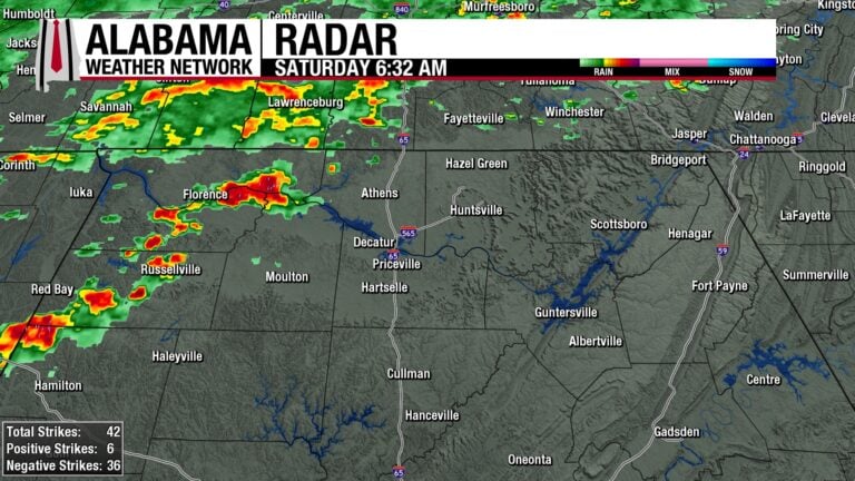
ALABAMA THIS MORNING
Already busy this morning with storms pushing into northwest Alabama. These are staying below severe limits. They could pack a punch though with heavier rain, wind gusts to 40 mph.
ALABAMA WEATHER FORECAST
SEPTEMBER COOL FRONT BRINGS RELIEF
Overnight storms have pushed east into Georgia, and a cold front is slipping into Alabama this morning. It marks the transition from a steamy early September stretch into a much more comfortable pattern for the state. Today begins with showers and a few stronger storms along and ahead of the boundary, but the afternoon and evening trend drier and cooler.
STORMS EARLY, THEN CLEARING SKIES
Clusters of showers and thunderstorms will sweep across northern Alabama through the morning hours. With CAPE values topping 1000–2000 J/kg and modest shear, a few storms could produce gusty winds up to 50 mph and downpours capable of 1–2 inch per hour rainfall rates. By midday the front should push south and east, bringing improving conditions with skies gradually clearing.
COMFORTABLE CHANGE MOVES IN
Behind the front, cooler and drier air filters into the Tennessee Valley and central Alabama. Afternoon highs will only reach the mid to upper 70s north and lower 80s central and south, with dewpoints dropping through the day. By tonight, lows tumble into the 50s for much of the northern half of the state, while coastal spots hold near 60–70°F.
SUNDAY SUNSHINE AND LOW HUMIDITY
Sunday looks refreshing across Alabama. Highs will be in the mid-70s to near 80 in the north and low to mid-80s elsewhere under mostly sunny skies. Overnight lows fall into the low/mid 50s north and mid/upper 50s farther south. Humidity levels remain low, making it feel more like early fall than summer.
A DRY START TO THE WEEK
High pressure settles in through Monday and Tuesday, keeping skies mostly clear. Highs climb back into the low to mid-80s statewide with cool nights in the 50s inland and low 60s south. A few coastal showers may linger east of I-65 in Mobile’s area on Monday, but most of Alabama stays dry.
WARMING TREND BY MIDWEEK
As the upper trough weakens, warmer conditions return. Highs rebound into the upper 80s and even lower 90s by Thursday and Friday, though humidity levels remain fairly comfortable. Rain chances stay low, with only isolated showers near the southeast corner of the state early in the week.
FOOTBALL FORECAST
While enjoying the Auburn and Alabama tailgates today, keep an eye on the sky. With a front moving through, isolated showers and storms are possible, and a few could bring gusty winds.
In Auburn, fans can expect a mostly fair evening as the Tigers host Ball State at 6:30 p.m. There’s a chance for a few showers during the first half, with temperatures sliding through the 70s.
In Tuscaloosa, Alabama welcomes LA-Monroe at 6:45 p.m. A stray shower can’t be ruled out, but should not rain the entire game, with temperatures easing through the 70s during the game.
For UAB’s road matchup against Navy in Annapolis, MD at 2:30 p.m., showers and thunderstorms are more likely, and fans should prepare for possible interruptions. Kickoff temperatures will be in the low to mid-80s.
DANCING WITH THE STATS
Autumn made an early entrance across the Upper Midwest and Plains on Friday as several cities set remarkable cold-weather marks. Kansas City set a new record for coldest high with just 65°F, breaking a mark that had stood since 1905. Rochester, Minnesota also struggled to 58°F, erasing a record from 1956, while nearby Duluth tied its century-old coldest high of 52°F. Eau Claire, Wisconsin set a new record cold high of 58°F, toppling records from 1933 and 1956. Out on the Plains, Rapid City, South Dakota dipped to 35°F, a new daily record low.
NATIONAL FORECAST: FROM FREEZE WARNINGS TO SEVERE STORMS
A strong early-September cold front continues its eastward push today, triggering severe thunderstorms across the Northeast and northern Mid-Atlantic. Along the I-95 corridor, damaging winds, hail, and even a few tornadoes are possible. The same corridor is also under a Slight Risk for excessive rainfall, raising the flash flood threat for urban areas, small streams and low-lying spots.
Farther south, showers extend into the Appalachians, Tennessee Valley and lower Mississippi Valley, while a lingering boundary over Florida keeps scattered thunderstorms in play through the weekend. Across the West, monsoonal storms and a Pacific trough bring chances for heavy downpours across the Southwest and Rockies, while the Pacific Northwest stays unsettled.
Behind the front, Frost Advisories and Freeze Warnings blanket the Upper Midwest, with lows dipping into the 30s and highs only in the 50s and 60s. The chill spreads eastward into the Great Lakes and Ohio Valley by Sunday. Looking ahead, the extended outlook keeps an amplified pattern in place: a central U.S. ridge flanked by troughs on both coasts. Rain persists in Florida and along the Southeast coast, while multiple days of steady, cool-season rainfall develop across the Northwest and Intermountain West.
NATION’S HOTTEST & COLDEST
The mercury soared to 111°F in Death Valley, California, marking the nation’s high for Friday. On the other extreme, a brisk 25°F was recorded 13 miles north of White Sulphur Springs, Montana, the nation’s low.
SEVERE OUTLOOK: SLIGHT RISK FOR NORTHEAST SEVERE STORMS
A cold front sweeping across the Northeast will spark scattered strong to severe thunderstorms this afternoon and evening from eastern Pennsylvania and New Jersey into southern New England. Damaging winds are the primary hazard, but hail and even a brief tornado or two cannot be ruled out. Farther south into the Piedmont, isolated storms could still bring gusty winds before activity weakens near the coast tonight.
FLASH FLOOD RISK TARGETS THE NORTHEAST
Heavy rainfall is expected to line up along the I-95 corridor from Philadelphia through New York City, where a Slight Risk has been issued for excessive rainfall today. Multiple rounds of storms could produce several inches of rain over urban areas during peak heating, raising the likelihood of flash flooding despite recent dryness. Elsewhere, Marginal Risks stretch into Virginia, the Tennessee Valley, the Florida Peninsula and across the monsoon belt of the Southwest and Four Corners region, where isolated flooding remains possible.
The Weather Prediction Center places the northern half of Alabama under a Marginal Risk for excessive rainfall today. Showers and storms along the advancing cold front could drop locally heavy downpours, but the fast-moving nature of the system should limit widespread flooding. Even so, isolated flash flooding remains possible in low-lying or poor-drainage areas.
TROPICAL WAVE LOSING STEAM
The National Hurricane Center continues to monitor a tropical wave in the central Atlantic, labeled AL91. Showers and storms remain disorganized, and conditions are only marginally favorable for development. Chances of this system becoming a tropical depression have dropped further, now sitting at 30% over the next 48 hours and 30% through seven days. The wave will track west at 10 to 15 mph and is expected to approach the Lesser Antilles by midweek, where interests should continue to follow its progress.
BEACH FORECAST
Along the beautiful beaches of Alabama and northwest Florida, expect another inviting late-summer day. Surf heights run around 1 foot, with water temperatures in the mid-80s. The rip current risk is low from Dauphin Island to Pensacola and Navarre, though swimmers should always use caution near piers, jetties, and inlets. Farther east toward South Walton, the risk increases to moderate, so swimming near lifeguards is strongly advised. Skies will be partly to mostly sunny, with highs in the upper 80s to near 90 and northeast winds turning southerly this afternoon. The UV Index is very high, so don’t forget the sunscreen.
ON THIS DAY IN ALABAMA WEATHER HISTORY
On September 6, 1925, The Birmingham News blared the headline: “Flaming Sun Sets on Hottest Day in Alabama.” The day before, Centreville in Bibb County had reached a blistering 112°F, a mark that still stands as the state’s hottest temperature on record. The oppressive heat gripped much of Alabama, layered on top of the worst drought in the state’s history. Farmers in East Alabama hauled water just to keep livestock alive, while streams and wells dried up across central counties. Crops suffered devastating losses, and the misery was not confined to Alabama — extreme heat and drought plagued much of the South and Midwest. Birmingham itself hit 106°F, matching the all-time city record set just the day before.
For more weather news and information from Bill Murray and the rest of the James Spann team, visit the Alabama Weather Network.