Bill Murray: Storms for Alabama today, sizzle by the weekend

TODAY: Scattered to numerous showers and thunderstorms will develop again today across north and central Alabama, mainly from late morning through early evening. Some stronger storms could produce gusty winds, frequent lightning and very heavy rainfall. The Storm Prediction Center has outlined the extreme northwest corner of Alabama in a marginal risk (level 1 of 5) for severe weather this afternoon and evening, with isolated damaging wind gusts the primary concern. Highs today will top out in the mid to upper 80s.
Showers and storms will gradually diminish after sunset as daytime heating is lost. Low clouds and patchy fog may form overnight in areas that received heavy rainfall earlier in the day. Overnight lows will settle into the lower 70s.
REST OF THE WEEK: Another round of scattered showers and thunderstorms is expected Wednesday afternoon and evening. Coverage may be a bit higher than today as a weak midlevel disturbance moves across the region. The greatest coverage may focus across northern and northeastern Alabama, where instability will be slightly higher. A few stronger storms could produce gusty winds and heavy downpours. High temperatures will remain in the mid to upper 80s.
Thursday brings an uptick in rain chances as a more organized midwest trough approaches. The Storm Prediction Center has placed parts of northeast and east-central Alabama in a marginal risk for severe storms Thursday afternoon and evening, with damaging winds the main hazard. On Friday, we begin transitioning into a hotter, somewhat drier pattern. Only isolated afternoon thunderstorms are expected, with highs returning to the upper 80s to near 90.
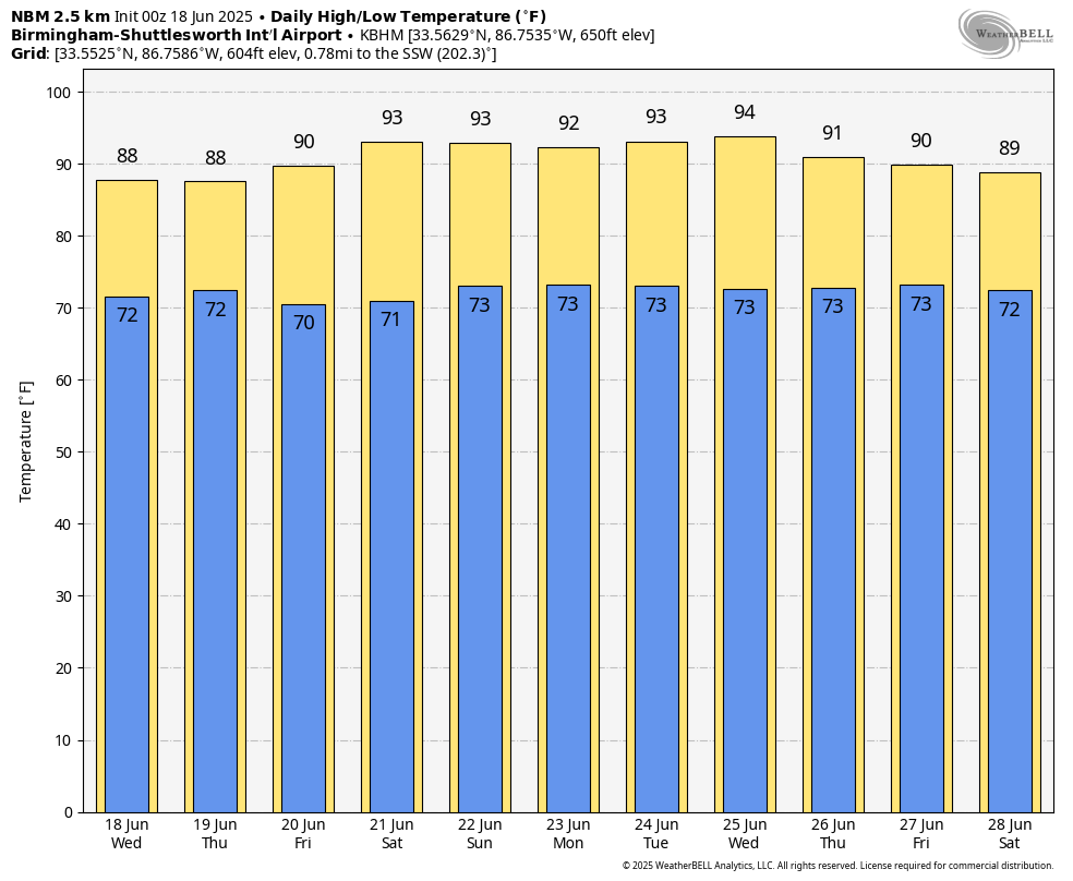
THE WEEKEND: A strengthening upper ridge will build over the Southeast this weekend and into early next week, leading to hot and mainly dry conditions. Highs each day will reach the lower to mid 90s, with only isolated afternoon thunderstorms possible. The heat index may approach or exceed 100 degrees by Sunday and Monday.
ON THIS DATE IN 1815: The Battle of Waterloo was affected heavily by weather. On June 16, Napoleon struck the Prussians at Ligny in Belgium. The French won the battle but suffered large casualties. Thunderstorms and heavy rain kept French troops from using their muskets effectively. On June 17, Napoleon turned his attention to Wellington’s Anglo-Dutch forces. A thunderstorm began as the battle began, with heavy rain continuing through the afternoon. Mud slowed the French advance. By June 18, clearing skies gave way to Prussian counterattacks that sealed Napoleon’s defeat.
For more weather news and information from James Spann, Bill Murray and other members of the James Spann team, visit AlabamaWx.