Bill Murray: Warm, humid weekend for Alabama

TODAY: The calendar keeps inching closer to summer’s peak, and the days are about as long as they get. With the solstice coming Friday evening at 9:41 p.m., we’re settling into a pattern typical for mid-June in Alabama: warm, humid air with daily rounds of showers and thunderstorms. Saturday will fit the script perfectly, with another dose of instability, high moisture and scattered storms — none expected to be severe, but some with a punch. After a week that featured multiple rounds of organized storms and local flooding, the weekend offers more of the hit-or-miss variety. We’ll also start to see temperatures climbing a little higher heading into next week, flirting with early heat advisory territory by midweek.
An upper trough over the Mississippi Valley will gradually shift east Saturday, maintaining enough lift aloft to interact with our moisture-rich air mass and spark scattered convection. Showers and thunderstorms will develop mainly during the afternoon, with coverage peaking mid to late afternoon. Rain chances are highest across the central and southern parts of the state, where deeper moisture and daytime heating will overlap. The main threats will be locally heavy rain, gusty winds and frequent lightning, especially with slower-moving storms.
Saturday will be warm and very humid. Morning lows will be in the low 70s across most of central and south Alabama. Highs will top out in the mid to upper 80s, tempered by cloud cover and scattered showers. Expect pockets of sunshine between rounds of rain. The best storm chances will occur between 1 and 7 p.m.; Saturday night will be mostly quiet with lows back in the lower 70s, although some showers may linger into the evening before gradually dissipating overnight.
THE WEEK AHEAD: Sunday through Wednesday will bring continued chances for afternoon and evening storms. Rain coverage looks highest Sunday and Monday, then slightly reduced by midweek. High temperatures will climb gradually each day, reaching the upper 80s and eventually brushing 90 degrees for many by Wednesday. The heat index will rise as well, approaching the upper 90s to near 100 by midweek in spots. While this isn’t extreme by Alabama standards, it will be enough to warrant caution for outdoor plans, especially for vulnerable groups. Overnight lows will stay muggy, in the low to mid 70s.
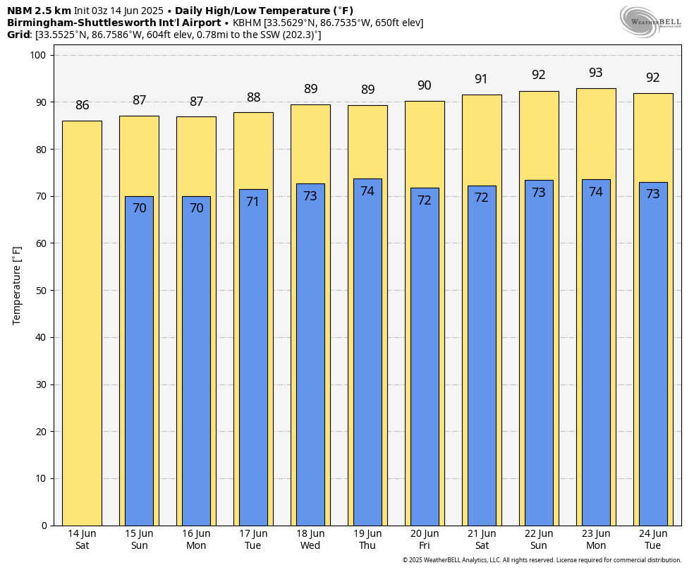
THE SUMMER SOLSTICE: The summer solstice arrives at 9:41 p.m. next Friday, June 20, marking the official start of astronomical summer — even though it’s already felt that way for a while. Friday and next weekend look seasonably hot and unsettled, with highs near 90 and daily scattered thunderstorms remaining in the forecast.
For more weather news and information from James Spann, Bill Murray and other members of the James Spann team, visit AlabamaWx.