Drew McCombs: Cloudy Monday in Alabama with spotty showers

ALABAMA YESTERDAY
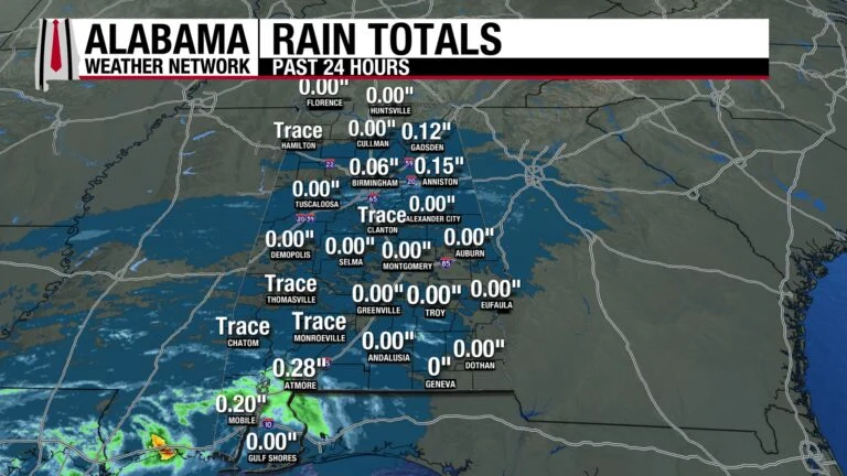
Early on the first day of winter, light showers moved from west to east across north-central Alabama, with rainfall totals remaining under 0.2 inches. Showers fizzled out in the afternoon and redeveloped in southwestern Alabama through the evening, where Mobile received 0.20 inches and Atmore measured 0.28 inches. Highs hit the low 60s in north Alabama, while rain and clouds kept the high in the upper 50s. South Alabama topped out at the low to mid 70s.
ALABAMA THIS MORNING
Showers linger west of Atmore, and clouds cover most of the state. Northwest Alabama is comparatively cooler than the rest of the state, with Florence at 35 degrees and surrounding areas in the 40s. Central Alabama sits in the low to mid 50s, and south Alabama is in the upper 50s, lower 60s.
Our Regions Dauphin Island cam captures the gloomy Monday morning on the coast.
The early-riser-Skywatchers are reporting temperatures in the upper 40s and low 50s.
Join the team! Learn how to become a Spann Skywatcher: https://www.spannskywatchers.com/

ALABAMA 7 DAY FORECAST
Clouds will persist throughout the day, keeping temperatures mild. Today marks the beginning of a Christmas-week warm-up as upper-level ridging begins to build over the region, pushing highs 15 to 20 degrees above average. Rain chances remain low through Tuesday morning, with dry weather expected beyond that.
MOSTLY CLOUDY MONDAY
Clouds will blanket the state throughout the day, and the southern showers will drift northward through the morning. A slight chance of rain lingers in North Alabama, though any rainfall will be minimal. Despite the clouds, highs will be in the upper 50s north, low to mid 60s in central Alabama, and upper 60s-low 70s south.
MILD NIGHT
Clouds will remain over most of the state tonight, keeping lows in the 50s. The temperature gradient will go from lower 50s in the east to higher 50s in the west, and with a chance for a few eastern locations dipping into the upper 40s. Light rain may fall in North Alabama through the night.
WARMING TUESDAY
Cloud cover will finally begin to clear out by Tuesday afternoon, allowing highs to range from the mid to upper 60s north to upper 60s and low 70s south. Patchy to dense fog is expected starting Tuesday night across South Alabama.
THE RISE CONTINUES CHRISTMAS EVE
As upper-level ridging strengthens, high temperatures will climb into the upper 60s in North Alabama and the low to mid 70s across central and South Alabama. Fog in the south is expected to persist and may make early morning/late evening holiday travel dangerous. Make sure to dress for the surprising warmth as you head to your holiday activities and use caution when driving in fog.
CHRISTMAS – WARMEST DAY OF THE WEEK
Christmas Day will be the warmest of the week, with highs reaching the low 70s in North Alabama and the mid 70s in the south. Chocolate milk might be a tad more refreshing than hot chocolate as you open your presents in the morning!
STILL WARM FRIDAY
Friday remains unseasonably warm, with highs in the upper 60s across north Alabama and the lower to mid 70s in the south.
WARMER TEMPS PERSIST INTO WEEKEND
Above-average temperatures continue into the weekend, with Saturday similar to Friday and slightly cooler conditions expected on Sunday.
WASH OUT IN CALIFORNIA
Heavy rainfall continues across California, where Eureka set a new daily rainfall record yesterday. A total of 2.37 inches fell, surpassing the 1964 record of 2.15 inches!
WINTRY WEATHER FOR THE GREAT LAKES AND NORTHEAST
A strengthening low-pressure system will bring light snow to the Upper Midwest on Monday, spreading into the Great Lakes and Northeast by Tuesday. Rain and freezing rain are possible along the rain–snow line across Pennsylvania, the central Appalachians and into southern New England, while heavier snow develops farther north.
RAIN SPREADS FROM THE GULF COAST TO THE OHIO VALLEY
Gulf moisture will bring rain to the central Gulf Coast through Monday before spreading into the Ohio and Tennessee Valleys and the Mid-Atlantic by Tuesday morning. Rain will retreat toward the Tennessee Valley by Tuesday evening as the system moves east.
HEAVY RAIN AND FLOODING CONCERNS IN CALIFORNIA
Persistent Pacific moisture will produce heavy rain across northern California on Monday, where a Moderate Risk (3/4) of Excessive Rainfall is in place, with flash flooding, river flooding, and debris flows possible. By Tuesday into Wednesday, heavy rain shifts into central and southern California under a Slight Risk (2/4), with localized flash flooding in urban areas, small streams, and burn scars, while snow falls at higher elevations.
NATIONAL HIGH AND LOW
La Puerta and Hidalgo, Texas, hit a high of 90 degrees yesterday, while Indus, Minnesota, fell to a low of –21 degrees. Neither extreme would be fun to experience.

UNSETTLED WATERS AND A MOSTLY SUNNY DAY
Mostly sunny skies and highs in the upper 60s will make for a pleasant beach day. Winds will be around 15 mph, which might put a slight damper on conditions. Rip current risk is moderate, and surf height is 2 to 3 feet, so exercise caution if you enter the water and be sure to swim near a lifeguard. Fog is possible in the evening into the morning. Lighter winds and warmer temperatures set the stage for an even better beach day tomorrow.

TODAY IN WEATHER HISTORY
December 22, 2011- Another Outbreak in a Relentless Season
In a year already defined by devastating outbreaks, Alabama faced yet another round of severe weather just three days before Christmas. On December 22, a stalled front and unusually warm, unstable air triggered a late-season tornado outbreak across the Southeast. Alabama recorded six tornadoes — all EF0 or EF1 — beginning with two EF0s in Bibb County shortly after noon. Additional EF0s affected Dallas, Shelby and Autauga Counties, while the strongest tornado, an EF1, tracked nearly 25 miles from Elmore through Coosa and into Tallapoosa County, destroying a large metal building near Highway 280. Despite scattered damage to homes, mobile homes and trees, Alabama saw no injuries — a fortunate outcome in an already relentless tornado season.

IMAGE OF THE DAY
Inga Sarda-Sorensen tagged James Spann in this gorgeous picture of the New York City skyline glowing in the sunset on the Winter Solstice. View the post on X.
For more weather news and information from Drew McCombs and the rest of the James Spann team, visit the Alabama Weather Network.