James Spann: Alabama has a small chance of some isolated showers Wednesday as dry pattern continues
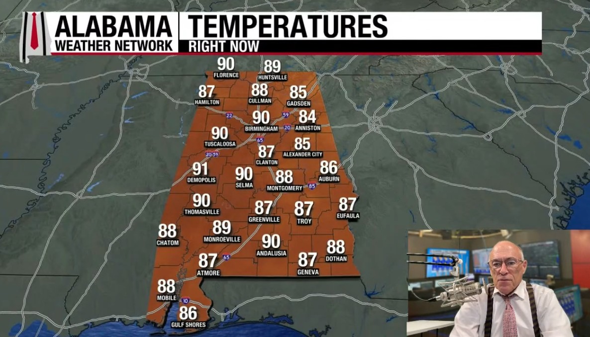
RADAR CHECK: Most all of Alabama is rain-free this afternoon … we do note a few isolated showers between Roanoke and Alexander City. The rest of the state is mostly sunny with temperatures in the upper 80s and low 90s. Any isolated showers will end this evening; the sky will be mostly fair tonight with a low in the 60s.

The chance of rain each day through the weekend across Alabama is not zero, but showers will remain few and far between as a dry pattern continues. The sky will be partly to mostly sunny each day with highs in the upper 80s and low 90s. Humidity levels will remain fairly low, however, and nights will be pleasant with lows generally in the 60s. The chance of any one spot seeing rain each afternoon is 10% or less.
NEXT WEEK: New model runs this morning don’t give us much hope for rain next week other than a few isolated showers. Highs next week will be in the mid to upper 80s … See the video briefing for maps, graphics and more details.

TROPICS: Showers and thunderstorms associated with an elongated area of low pressure (Invest 92L) located about midway between the Windward Islands and the Cabo Verde Islands have become better organized since yesterday. Environmental conditions are conducive for additional development, and a tropical depression or storm is likely to form in the next day or two as the system moves west-northwestward or northwestward at 10 to 15 mph over the central tropical Atlantic.
NHC gives this feature a 90% chance of development; it will turn north into the open Atlantic and is no threat to land.

Also … a tropical wave just offshore of the west coast of Africa is producing an area of disorganized showers and thunderstorms. Some slow development of this system is possible towards the latter part of this week as it moves westward at 15 to 20 mph, moving from the eastern to central portion of the tropical Atlantic. The chance of development for now is 20%.

No tropical storms or hurricanes are expected across the Gulf for at least the next 7-10 days.
ON THIS DATE IN 2004: At 51 minutes after midnight on 16 September 2004, the northern eye wall of powerful Hurricane Ivan moved onto land near Gulf Shores as an upper end Category 3 hurricane.
Bringing with it 130 mph surface winds and a 12-foot storm surge, estimates show that the magnitude and extent of the damage and destruction over Baldwin County and Escambia and Santa Rosa counties of Northwest Florida likely exceeded that of both Hurricane Frederic (September 1979) and Hurricane Opal (October 1995). Additionally, Hurricane Ivan was very close to the magnitude of damage and destruction caused by the Hurricane of 1926 which ravaged the aforementioned counties east of Mobile Bay.
Ivan produced estimated maximum winds of 60 to 80 mph generally southwest of line from Prattville to Livingston. A few spots may have reached 90 mph in this area. Most other locations across central Alabama had estimated maximum wind speeds of 50 to 60 mph, with a few isolated spots reaching 75 mph. Damage was severe well inland … some of the hardest hit communities included Atmore, Brewton, Evergreen, Monroeville, Camden and Demopolis.
ON THIS DATE IN 2020: Hurricane Sally made landfall in Gulf Shores as a strong Category 2 hurricane with maximum sustained winds of 105 mph. Sally produced widespread wind, storm surge and freshwater flooding across coastal Alabama and the western Florida Panhandle. Flood and wind damage also extended well inland into southwest Alabama and south central Alabama.
Sally was an extremely slow-moving hurricane, which prolonged and exacerbated the local impacts. The storm was moving at less than 5 mph at the time of landfall, resulting in a long duration of tropical storm and hurricane force winds, storm surge and torrential rainfall.
There were three direct fatalities as a result of Sally. One fatality occurred in the Wolf Bay area (Baldwin County) Two men were riding the storm out on their boat and at some point during the storm attempted to swim to shore. One of the men made it to a pier and was rescued and hospitalized; the other man drowned.
For more weather news and information from James Spann and his team, visit the Alabama Weather Network.