James Spann: Alabama mostly dry today; Hurricane Helene likely to form in Gulf this week

EYES ON THE GULF: Alabama’s weather will be mostly dry today with a high in the low 90s. Heat levels won’t change much Tuesday, but a few strong storms are possible over the Tennessee Valley of north Alabama, where the Storm Prediction Center has defined a marginal risk (level 1 out of 5) of severe thunderstorms. The main threat will come from small hail and strong, gusty winds; the rest of the state will likely stay dry.
Rain becomes likely Wednesday ahead of a surface front, and the weather looks windy and wet Thursday as the tropical system moves inland and is pulled to the northwest. Periods of rain are still likely on Friday, but the weekend will be drier with a few lingering, scattered showers Saturday and Sunday.
INVEST 97L: The disturbance in the western Caribbean is expected to become Hurricane Helene by Wednesday. This morning the system hasn’t formed yet, and there is no well-defined low-level center. Once that happens, and we get dropsonde data from hurricane hunters, model data can be trusted more.
Here are some key messages early this morning:
- Models are tightly clustered, with landfall probabilities highest around Apalachicola, Cape San Blas and Indian Pass on Thursday. But the range of possibilities extends from near Destin all the way over to Cedar Key.
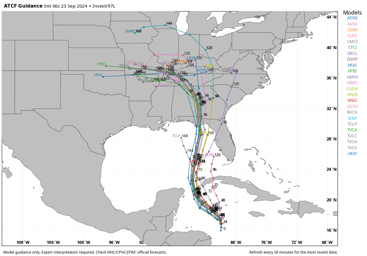
- The National Hurricane Center should declare Invest 97L a potential tropical cyclone later today; at that time, it will initiate advisories. As you look at the forecast track, remember the main impact in terms of storm surge, wind and freshwater flooding will be along and east of the point of landfall. And, of course, a hurricane is not a dot on a map; the impact will extend far from the center. There will be wind and storm-surge impact on Florida’s west coast as well (places like Tampa and St. Pete).
- It continues to appear that the Alabama Gulf Coast will be on the drier, good, west side of the circulation with an offshore flow.
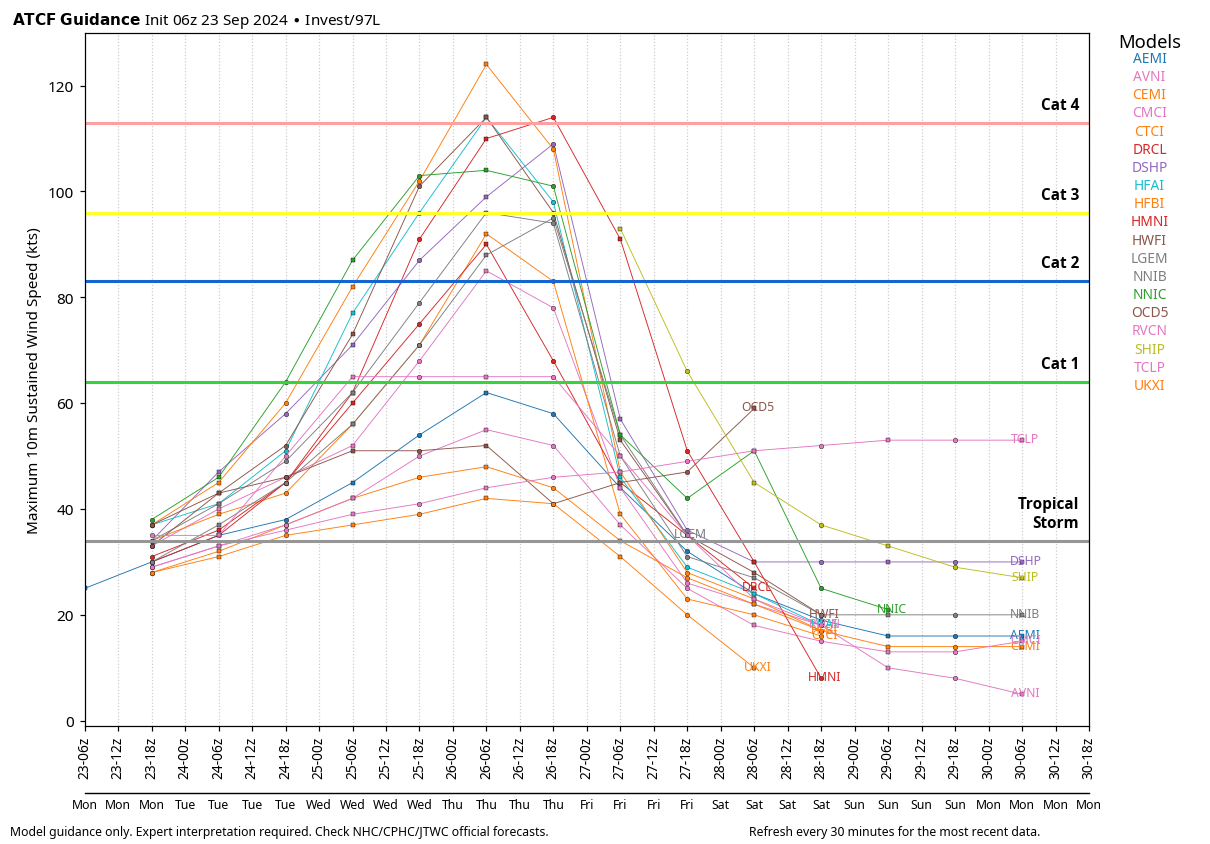
- Intensity guidance has a big spread, all the way from a minimal hurricane to a Category 4. Those along the coast will need to plan for the worst-case scenario. There is much more to forecasting hurricane intensity than sea surface temperatures; hopefully, westerly shear will help to keep this tropical cyclone from any rapid intensification before landfall, but we don’t know that yet.
Once inland, Helene will be pulled to the northwest, rotating around an upper low over Arkansas. This is known as the Fujiwhara effect, which is pretty unusual at this latitude. The tropical system and the upper low will basically rotate around each other.
With this northwest motion, the weather in inland parts of Alabama will be windy and very wet Thursday. It is still too early for an impact forecast for any given location, but the general idea is that the eastern half of Alabama could see 3-5 inches of rain Wednesday through Friday, with 2-4 inches for the western counties.
The weekend across Alabama will be much drier, and we expect only scattered showers Saturday for the college football games.
All of this could easily change; once the system actually forms, confidence in the forecast will be much higher and we can make specific impact forecasts. With tropical systems, when you are working with old information, you are working with bad information.
 ON THIS DATE IN 1975: Hurricane Eloise made landfall as a major hurricane east of Fort Walton Beach and Destin around 7 a.m. on Sept. 23, 1975. Eloise was the first major hurricane to strike the region in four decades.
According to the NOAA assessment, Herbert Saffir estimated winds in excess of 120 mph based on the structural wind damage he observed in Eloise. Shortly after Eloise made landfall, a peak wind gust of 115 mph was recorded at Eglin Air Force Base (before the instrument failed) with 85 mph gusts at Hurlburt Field. Eloise weakened as it pushed inland across Alabama through the day.
For more weather news and information from James Spann and his team, visit AlabamaWx.