James Spann: Alabama rain chances increase Tuesday; temperatures stay below average

SCATTERED SHOWERS/STORMS MORE NUMEROUS: With rising moisture levels and the air becoming more unstable, we expect a general increase in the number of scattered showers and thunderstorms across Alabama through the week. The chance of any one spot seeing rain today is 30-40%, 70-80% tomorrow, and 50-60% Wednesday through Friday. Most, but not all, of the showers will come from around noon to midnight.
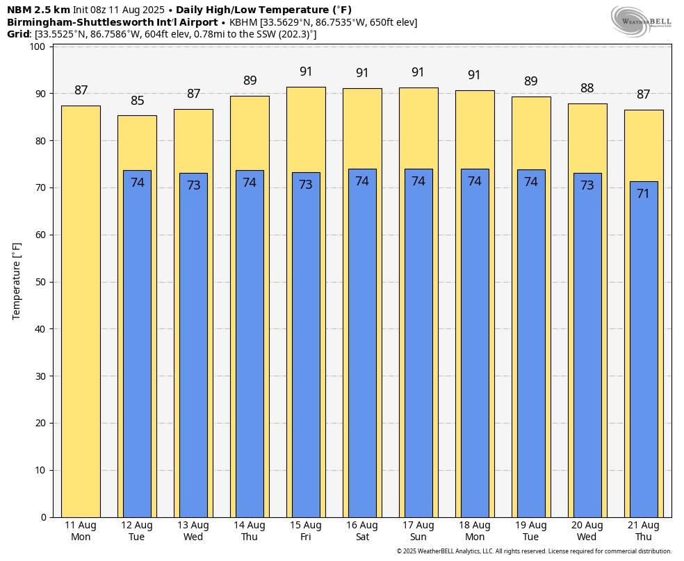
Temperatures will remain generally below average for mid-August. Highs will be in the 85-90 degree range for most communities through Thursday, followed by low 90s Friday.
THE WEEKEND: We expect routine summer weather for Alabama and the Deep South over the weekend … partly sunny days with the usual daily rounds of “scattered, mostly afternoon and evening showers and thunderstorms”. Highs will be in the low 90s, right at seasonal averages for August.
The weather won’t change much through next week, although global models suggest highs could drop back into the upper 80s over the latter half of the week.
TROPICS: A well-organized tropical disturbance in the eastern Atlantic (Invest 97L) will likely become a tropical depression today. There is a good chance it becomes a hurricane later this week, the first of the season (the name will be Erin).
A weakness in the upper ridge north of the system should allow for a turn northward into the open Atlantic well before reaching the U.S. East Coast.


No tropical storms or hurricanes are expected across the Gulf for at least the next seven days.
ON THIS DATE IN 1940: A Category 2 hurricane struck the Georgia and South Carolina coast. A 13-foot storm tide was measured along the South Carolina coast, while over 15 inches of rain fell across northern North Carolina. Significant flooding and landslides struck Georgia, North Carolina, Tennessee and Virginia during the system’s slow trek as a weakening tropical storm, and then as an extratropical cyclone, through the Southeast. The landslides which struck North Carolina were considered a once in a century event. Damages relating to the storm totaled $13 million (1940 USD), and 50 people perished.
ON THIS DATE IN 1999: An F2 tornado touched down in the metropolitan area of Salt Lake City. The tornado lasted ten minutes and killed one person, injured more than 80 people and caused more than $170 million in damages. It was the most destructive tornado in Utah’s history and awakened the entire state’s population to the fact that the Beehive State does experience tornadoes.
BIG DAY: The Alabama Weather Network launches at noon today!
The AWN apps are available now:
Apple: https://apps.apple.com/…/alabama-weather…/id6748039126
Google: https://play.google.com/store/apps/details?id=com.awn.wx…
Also look for the AWN apps for your TV … Roku, Apple TV, Chromecast, Amazon Fire are all available a little later this morning (by 11 a.m.)
For more weather news and information from James Spann and his team, visit the Alabama Weather Network.