James Spann: Alabama trending drier by the weekend; new activity in the Gulf

RADAR CHECK: Torrential rain has been falling this morning across parts of Mobile and Baldwin counties thanks to a small scale low that moved in from the Gulf. Radar estimates suggest 16 inches of rain at Point Clear since it started. This is probably overdone, but amounts of 8-10 inches of rain are certain along parts of the eastern shore. Flooding is likely serious in spots from Spanish Fort down to Point Clear.
Remember, turn around, don’t drown! Never drive across a flooded roadway; you have no idea how deep the water is, or if a road is washed out. A flash flood warning remains in effect for eastern Baldwin County.

Scattered storms are over the northern third of the state at daybreak; the central counties are mostly dry. Scattered to numerous showers and storms are likely today with highs in the 80s.
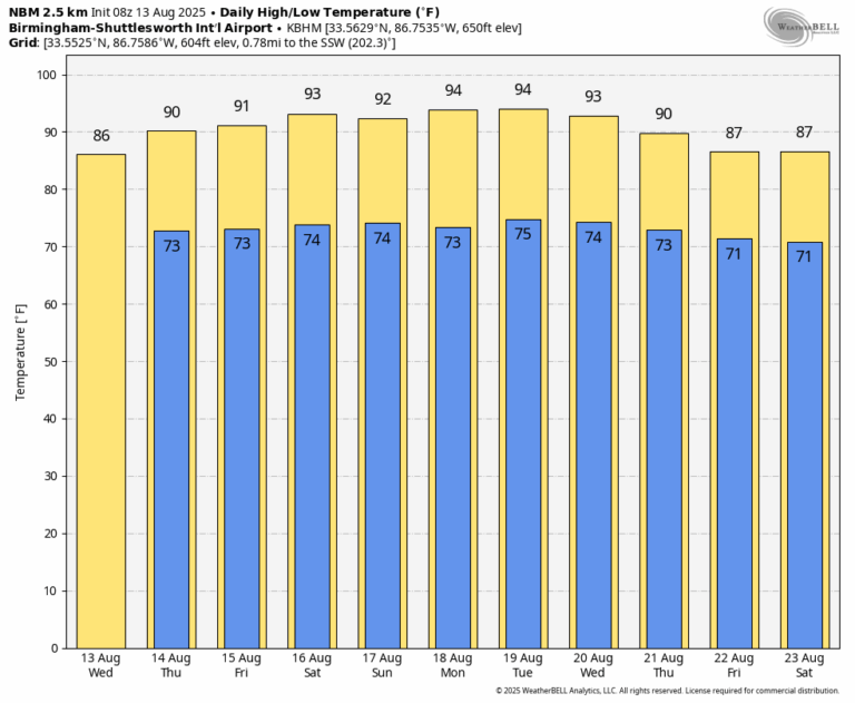
Tomorrow will feature a partly sunny sky with a shower or storm in scattered spots, but the weather will trend drier by Friday and the weekend as the upper ridge rebuilds over the region. A shower or storm is certainly possible on these three days, but they should be isolated. Heat levels creep up with highs in the low to mid 90s in most places.
NEXT WEEK: Highs will remain in the 91-95 degrees range for the first half of the week with just a few isolated afternoon storms; showers and storms should be more numerous by Thursday and Friday as the upper ridge begins to weaken. Highs drop into the upper 80s late in the week.
TROPICS: Tropical Storm Erin in the Atlantic is expected to become a hurricane tomorrow night or Friday. It will pass north of the Leeward Islands and Puerto Rico, followed by a turn to the north east of the Bahamas thanks to a weakness in the upper ridge north of the system. Erin is no threat to the U.S. … but it could be close to Bermuda in 6-7 days.

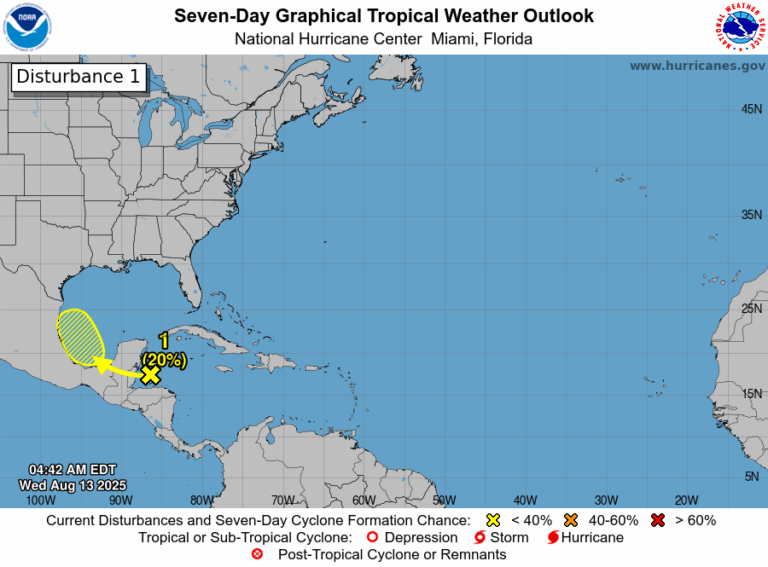
Elsewhere, a tropical wave over the northwestern Caribbean Sea is producing disorganized showers and thunderstorms this morning. This disturbance is forecast to move west-northwestward and cross the Yucatan Peninsula later today with no significant increase in organization. Some development of this system is possible after it emerges across the southwestern Gulf beginning on Thursday while the system moves to the west-northwest or northwest at 10 to 15 mph.
NHC gives this feature a 20% chance of development; it will likely move into Mexico by the weekend.
ON THIS DATE IN 1987: A succession of thunderstorms produced rainfall that was unprecedented in 116 years of precipitation records at Chicago, Illinois during an 18 hour period from the evening of the 13th to the early afternoon of the 14th. The resulting flash flood was the worst ever to strike the Chicago metropolitan area, causing three deaths and water damage that amounted to $221 million. O’Hare International Airport received an event total of 9.35 inches of rain in 18 hours, shattering the previous 24-hour record of 6.24 inches. For about 24 hours, the airport was only accessible from the air as all roads were blocked by high water, including the Kennedy Expressway.
For more weather news and information from James Spann and his team, visit the Alabama Weather Network.