James Spann: Alabama will see less likelihood of rain, increased highs the rest of the week

RADAR CHECK: We have scattered to numerous showers and thunderstorms across Alabama this afternoon in a tropical airmass that covers the state. Stronger storms are producing torrential rain and frequent lightning. Temperatures remain below average with most communities in the 75-85 degree range; where the sun is out we have upper 80s.
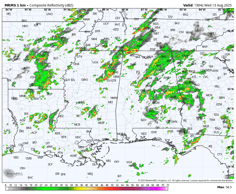
Showers and storms will fade tonight after sunset.
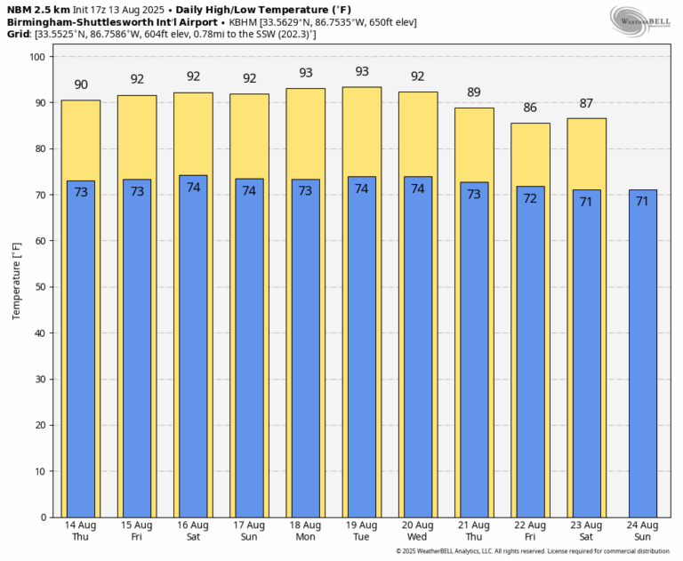
Tomorrow will feature a partly sunny sky with a shower or storm in scattered spots, and the weather will continue to trend drier by Friday and the weekend as the upper ridge rebuilds over the region. A shower or storm is certainly possible on these three days, but they should be isolated. Heat levels creep up with highs in the low to mid 90s in most places.
NEXT WEEK: Highs will remain in the 91-95 degrees range for the first half of the week with just a few isolated afternoon storms; showers and storms should be more numerous by Thursday and Friday as the upper ridge begins to weaken. Highs drop into the upper 80s late in the week … See the video briefing for maps, graphics, and more details.
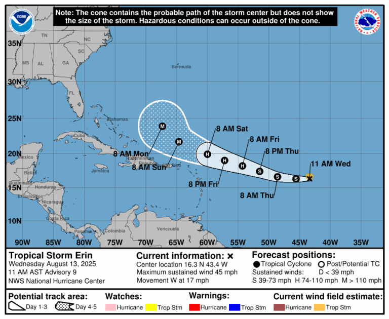
TROPICS: Tropical Storm Erin in the Atlantic is expected to become a hurricane Friday. It will pass north of the Leeward Islands and Puerto Rico, followed by a turn to the north, east of the Bahamas, thanks to a weakness in the upper ridge north of the system. Erin is no threat to the U.S… but it could be close to Bermuda in 6-7 days.
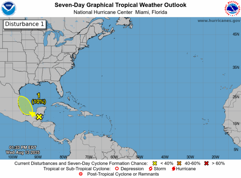
Elsewhere, a tropical wave over the Yucatan Peninsula is producing disorganized showers and thunderstorms. This disturbance is forecast to move
west-northwestward and cross the Yucatan Peninsula today with no significant increase in organization. Some development of this system is possible after it emerges across the southwestern Gulf beginning tomorrow while it moves to the northwest at 10 to 15 mph. The system is expected to move inland over northeastern Mexico by late Friday, which should diminish its chances of development.
NHC has dropped the chance of development to 10%.
ON THIS DATE IN 1987: A succession of thunderstorms produced rainfall that was unprecedented in 116 years of precipitation records at Chicago, Illinois during an 18 hour period from the evening of the 13th to the early afternoon of the 14th. The resulting flash flood was the worst ever to strike the Chicago metropolitan area, causing three deaths and water damage that amounted to $221 million. O’Hare International Airport received an event total of 9.35 inches of rain in 18 hours, shattering the previous 24-hour record of 6.24 inches. For about 24 hours, the airport was only accessible from the air as all roads were blocked by high water, including the Kennedy Expressway.
ON THIS DATE IN 2004: Hurricane Charley made landfall near the island of Cayo Costa, Florida as a 150 mph Category 4 hurricane with a pressure of 941 mb. Zolfo Springs was isolated for nearly two days as large trees, power poles, power lines, transformers and debris filled the streets. Wauchula sustained gusts to 147 mph; buildings in the downtown areas caved onto Main Street.
The storm passed through the central and eastern parts of the Orlando metropolitan area, carrying winds gusting up to 106 mph (171 km/h). The city of Winter Park, north of Orlando, also sustained considerable damage since its many old, large oak trees had not experienced high winds. Falling trees tore down power utilities and smashed cars, and their huge roots lifted underground water and sewer utilities. The storm slowed as it exited the state over Ormond Beach just north of Daytona Beach.
For more weather news and information from James Spann and his team, visit the Alabama Weather Network.