James Spann: Alabama’s rain chances are lower as temperatures go higher through the weekend

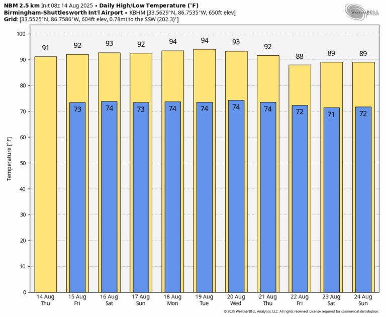
RADAR CHECK: Most of Alabama is rain-free at daybreak; we note just a few small showers over Choctaw and Washington counties. Look for a partly sunny sky today with a few random, scattered showers and thunderstorms this afternoon. The chance of any one spot seeing rain is 20-30%, and the high will be in the 89–93 degree range for most places as heat levels begin to slowly rise. Pretty much the same situation is expected tomorrow; best chance of an afternoon shower or storm will be over the southern half of the state.
THE ALABAMA WEEKEND: As the upper ridge continues to build, afternoon highs will be in the low- to mid-90s over the weekend with only isolated afternoon showers or storms. Many communities will be rain-free over the weekend.
Not much change is expected through the first half of next week. Highs will remain in the 90-95 degree range for much of the state with afternoon storms remaining very isolated. Global models suggest the ridge will weaken late in the week; highs drop into the upper 80s over the northern half of the state by Friday (August 22) with a better coverage of afternoon showers/storms.
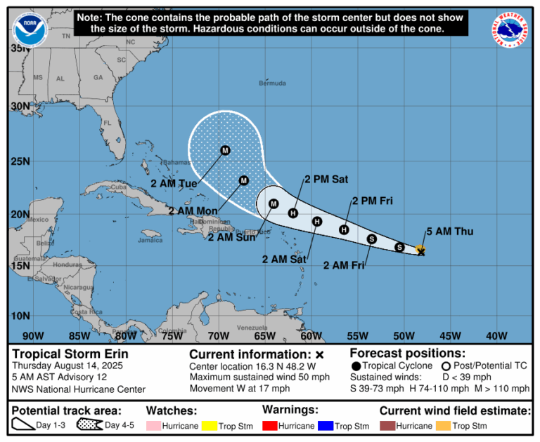
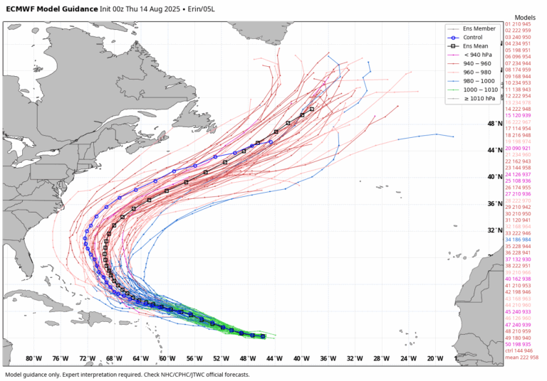
TROPICS: Tropical Storm Erin, with 50 mph winds, is in the middle of the Atlantic moving to the at 17 mph. The system is expected to become a hurricane late tonight or tomorrow. It will pass north of the Leeward Islands and Puerto, and then it turns north, east of the Bahamas, this weekend. By that time Erin is expected to become a major hurricane with winds of 125 mph (category three strength). Erin is expected to remain well east of the U.S. East Coast, but it could be closer to Bermuda by the middle of next week.
There is one other area of interest … a broad area of low pressure near the west coast of the Yucatan Peninsula is producing disorganized showers and thunderstorms. The broad low is forecast to emerge off the coast later this morning and move west-northwestward across the southwestern Gulf during the next day or two, where environmental conditions are marginally conducive for further development. The system is forecast to move inland over northeastern Mexico by late tomorrow, ending its chances of formation. Chance of development is only 20%; this will be mainly a rainmaker for eastern Mexico.
No tropical storms or hurricanes are expected across the northern Gulf for at least the next seven days.
ON THIS DATE IN 1953: Hurricane Barbara hits North Carolina as a Category 2 hurricane. Damage from the storm was relatively minor, totaling around $1.3 million (1953 USD). Most of it occurred in North Carolina and Virginia from crop damage. The hurricane left several injuries, some traffic accidents, as well as seven fatalities in the eastern United States; at least two were due to electrocution from downed power lines. Offshore Atlantic Canada, a small boat sunk, killing its crew of two.
ON THIS DATE IN 1969: Hurricane Camille, a powerful, deadly, and destructive hurricane formed just west of the Cayman Islands on this day. It rapidly intensified, and by the time it reached western Cuba the next day, it was a Category 3 hurricane. Hurricane Camille was spawned on August 5th by a tropical wave off the coast of Africa. The storm became a tropical disturbance four days later on the 9th and a tropical storm on the 14th with a 999-millibar pressure center and 55 mph surface winds. It would make landfall on August 17, 1969 on the Mississippi coast.
For more weather news and information from James Spann and his team, visit the Alabama Weather Network.