James Spann: August heat flexes in Alabama but cooler temperatures on the horizon
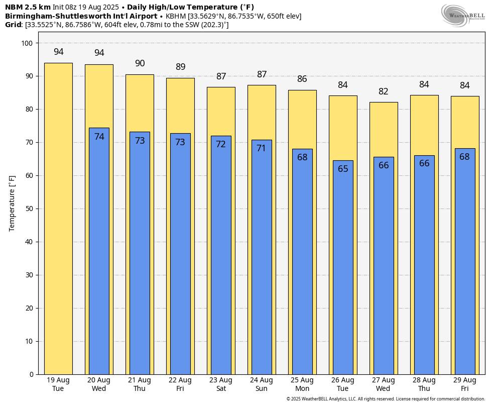
ANOTHER HOT SUMMER DAY: Most communities will see a high in the mid 90s across Alabama today with a partly to mostly sunny sky; afternoon thunderstorms will be isolated… chance of any one spot getting wet is 15-25%.
Then, over the latter of the week, we expect a trend with lower heat levels and a greater coverage of scattered showers and thunderstorms. By Friday the high will be in the 88-92 degree range with any one spot having 55-65% chance of seeing some rain. Most, but not necessarily all, of the showers and storms will come from noon to midnight.
THE ALABAMA WEEKEND: The upper ridge across the Deep South will continue to break down, and we expect scattered to numerous showers and thunderstorms both Saturday and Sunday. Not a weekend wash-out, but a passing shower or storm is likely from time to time. The sky will be cloudy at times, and highs will be mostly in the mid to upper 80s.
NEXT WEEK: Global models suggest a rare August cold front will pass through the state early in the week, which will bring dry, continental air into the Deep South. This means lower humidity levels and cooler nights… lows will be well down in the 60s by Tuesday and Wednesday morning, with potential for 50s for the cooler spots across North Alabama. A decent part of the week will be dry.
TROPICS: Hurricane Erin is weaker this morning. Sustained winds are down to 115 mph… the center is about about 675 miles southwest of Bermuda, and is moving to the northwest at 7 mph.
Erin will pass between the U.S. and Bermuda Thursday; from there the system heads quickly into the North Atlantic and becomes post-tropical this weekend.
The hurricane is expected to produce life-threatening surf and rip currents along the beaches of the Bahamas, much of the east coast of the U.S., Bermuda, and Atlantic Canada during the next several days. Beachgoers in those areas should follow advice from lifeguards, local authorities, and beach warning flags.


A tropical wave located over the central tropical Atlantic continues to produce a broad area of disorganized showers and thunderstorms. Environmental conditions appear conducive for gradual development of this system, and a tropical depression could form toward the end of the week or weekend. This system should move westward to west-northwestward at about 20 mph across the central tropical Atlantic and approach the vicinity of the Leeward Islands on Friday. NHC gives this feature a 60% chance of becoming a depression or tropical storm; all 51 members of the reliable European global model ensemble show it turning north into the open Atlantic well east of the U.S. No tropical storms or hurricanes are expected across the Gulf at least for the next 7-10 days.


For more weather news and information form James Spann and his team, visit the Alabama Weather Network.