James Spann: Colder days ahead for Alabama, with lows in the 30s

DRY DAYS: The sky is mostly sunny across Alabama this afternoon with a cool north breeze. Tonight will be clear and colder, with a low between 36 and 44 degrees.
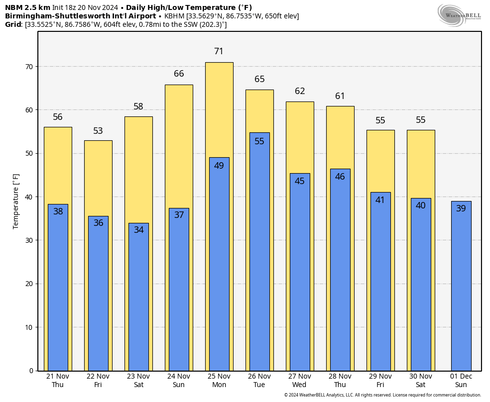
COLDER: The coldest air so far this season will continue to move into the state Thursday; temperatures hold in the 50s over the northern counties with a brisk north wind. Some parts of north Alabama won’t get out of the 40s Friday despite a sunny sky. Lows will be well down in the 30s both Friday and Saturday mornings, and parts of north Alabama will see freezing temperatures. Frost is likely across the southern counties.
The weather will stay dry over the weekend with sunny days and fair nights; highs will be between 57 and 64 degrees Saturday, followed by mid to upper 60s Sunday.
THANKSGIVING WEEK: A fast zonal flow will be in place, and timing out the various waves will be challenging. For now, we expect some risk of showers Tuesday, followed by dry air Wednesday. Some global model runs are suggesting Thanksgiving Day in Alabama could be wet and stormy, but there is great uncertainty with a fast-moving pattern.
TROPICS: The Atlantic basin is very quiet, and tropical storm formation is not expected for at least the next seven days. Hurricane season ends in 10 days.
FOOTBALL WEATHER: The weather will be clear and cold for the high school playoff games Friday night with temperatures falling through the 40s, possibly reaching the 30s by the fourth quarter.
On Saturday, UAB will host Rice at Protective Stadium (1 p.m. kickoff). The sky will be sunny with temperatures in the mid to upper 50s.
Auburn hosts Texas A&M at Jordan-Hare Stadium (6:30 p.m. kickoff). It will be a clear, cold evening in Lee County with temperatures falling through the 40s.
Alabama will be on the road, taking on Oklahoma in Norman (6:30 p.m. CT kickoff). Expect a clear sky with temperatures in the 50s.
ON THIS DATE IN 1900: A violent tornado roared through the town of Columbia in Maury County, Tennessee, killing 27 people.
ON THIS DATE IN 1985: Kate intensified to a major Category 3 hurricane as she moved west of Key West, Florida, with top winds of 115 mph and a minimum central pressure of 954 millibars or 28.17 inches of mercury. The next day Kate made landfall between Panama City and Apalachicola, Florida. Tides ran 8 to 10 feet above normal. Many power poles and lines were downed. Several roads were washed out.
For more weather news and information from James Spann and his team, visit AlabamaWx.