James Spann: Eyes on the Gulf; tropical rain for Alabama Thursday

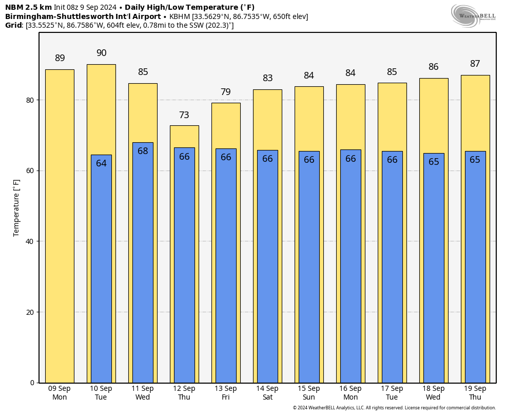
MOSTLY DRY THROUGH TUESDAY: While a few showers are near the Alabama Gulf Coast early this morning, the rest of the state is dry as the day begins. Temperatures are in the 50s north and west of Birmingham, but we warm quickly today, with highs between 87 and 92 degrees this afternoon. Any showers will remain near the Gulf Coast, and even there, rain amounts will be light and spotty.
Tuesday will be generally sunny for most of Alabama with a high around 90 degrees; showers remain confined to the far southern counties.
Clouds begin to increase ahead of a tropical system to the south, and widespread, soaking rain is likely Wednesday night and Thursday. Amounts of 2-4 inches are possible over the western half of the state, with 1-2 inches for the eastern counties. A low-end risk of a few isolated, brief tornadoes could develop on Thursday as the tropical low moves northward up the Mississippi River, but the air will be fairly stable. The lack of instability could mitigate any tornado threat, but we will still be watching radar very carefully.
A slot of dry air will begin to work into the state Friday, and the main risk of showers will be over the eastern half of the state.
THE ALABAMA WEEKEND: The remnant tropical low will meander around the region, and we will need to mention a chance of showers or storms both Saturday and Sunday. This won’t be a washout, but some rain is certainly possible at times. Highs will be in the low to mid 80s.
NEXT WEEK: The risk of showers will persist for at least the first half of the week with highs holding in the 80s.
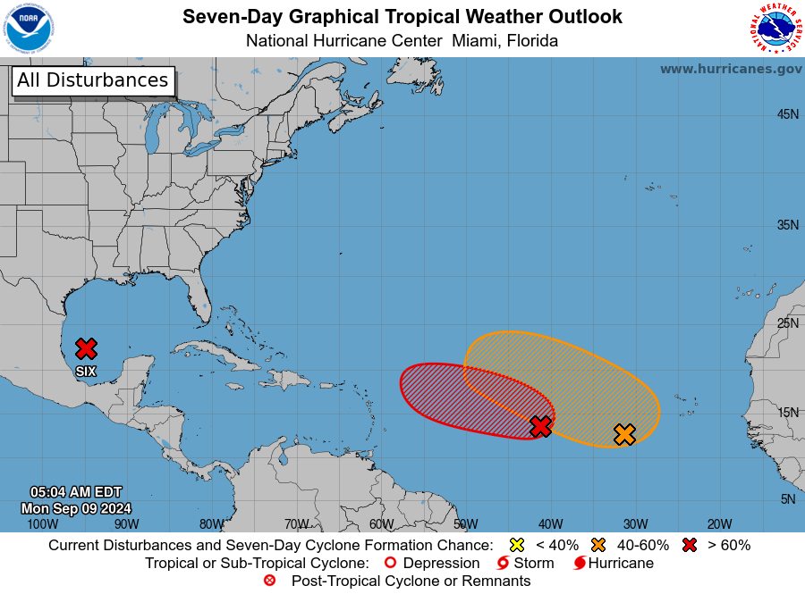
TROPICS: Potential Tropical Cyclone 6 in the southwest Gulf of Mexico is forecast to become Tropical Storm Francine later today. The system early this morning is about 535 miles south of Cameron, Louisiana, with winds of 50 mph. The system is moving to the north/northwest at 5 mph.
The National Hurricane Center (NHC) forecast has Francine making landfall on the coast of Louisiana east of Cameron late Wednesday afternoon as a Category 1 hurricane with 80 mph winds. Hurricane and storm surge watches will likely be issued for a portion of the Louisiana coast later today.
The main impact will be east of the circulation center; heavy rain will fall across southeast Louisiana and parts of Mississippi, Alabama and the Florida Panhandle. The rip-current danger will be high along the central Gulf Coast Tuesday night through Friday.
A few brief, isolated tornadoes are possible east of the center Wednesday night and Thursday across parts of southeast Louisiana, Mississippi and Alabama.
Elsewhere, the NHC is watching two features in the Central Atlantic, both with a good chance of development over the next seven days. They are far from land, and global models suggest they could gain latitude and turn north before reaching the Lesser Antilles; they are just something to watch for now.
ON THIS DATE IN 1965: Hurricane Betsy slammed into New Orleans, where 110 mph winds and power failures were reported. The eye of the storm passed southwest of New Orleans on a northwesterly track. The northern and western eyewalls covered southeast Louisiana and the New Orleans area from about 8 p.m. until 4 the next morning. In Thibodaux, winds of 130 mph to 140 mph were reported. The Baton Rouge weather bureau operated under auxiliary power, without telephone communication.
For more weather news and information from James Spann and his team, visit AlabamaWx.