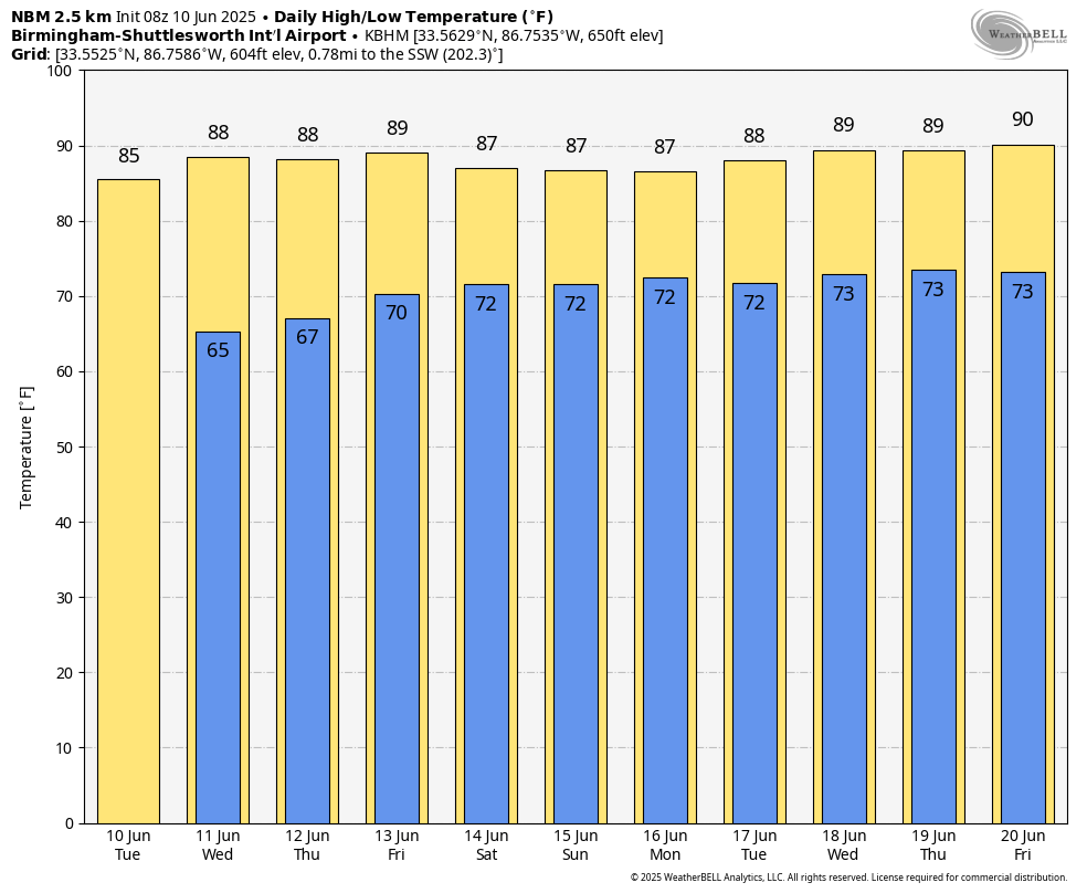
James Spann: Fewer showers in Alabama today, Wednesday

RADAR CHECK: We have a few isolated showers over north Alabama early this morning; otherwise, the state is dry with temperatures in the upper 60s and low 70s. Expect a partly sunny sky today with a high in the mid to upper 80s. Showers this afternoon will be widely spaced; odds of any one spot getting wet are 20-25%.
Wednesday will be much the same: partly sunny with just a few isolated afternoon and evening showers and storms, mainly over the southern counties.
THURSDAY THROUGH THE WEEKEND: Showers and storms will show an increase in coverage late this week and into the weekend, but they will still be scattered, and mostly during the afternoons and evenings. Each day expect a mix of sun and clouds with highs in the mid to upper 80s, right at seasonal averages for mid-June. Humidity will be very high with a tropical air mass in place across the Deep South. The chance of any one spot seeing rain each day will be 40-50%, and most (but not all) of the showers and storms will come from around 2 until 10 p.m. Organized severe storms are not expected, but any summer storm can produce strong, gusty winds and gobs of lightning.
NEXT WEEK: Expect pretty routine June weather — partly sunny, humid, very warm days with scattered, mostly afternoon and evening showers and thunderstorms daily. Highs will be between 87 and 91 degrees.
TROPICS: All remains very calm across the Atlantic basin, and tropical storm/hurricane formation is not expected for at least the next seven days.
ON THIS DATE IN 1997: Flash flooding occurred in many locations in Mississippi. U.S. Highway 80 and many other streets were flooded in and around Vicksburg. Water engulfed one person’s car, but the person was rescued.
ON THIS DATE IN 2005: Tropical Storm Arlene brought 2-4 inches of rain to the southern two-thirds of Alabama.
For more weather news and information from James Spann and his team, visit AlabamaWx.