James Spann: Helene to make landfall Thursday evening; heaviest rain over east Alabama

WET: We are forecasting occasional rain and a few thunderstorms across Alabama through tonight ahead of an upper trough and surface front. A few strong storms are possible this afternoon over east and south Alabama, where the Storm Prediction Center has defined a marginal risk of severe weather (level 1 of 5). Heavier storms could produce small hail and strong, gusty winds.
Rain continues at times Thursday and Thursday night, and it could be heavy at times over the eastern half of the state as Helene moves inland and up into Georgia. A flash flood watch is in effect for the area from Gadsden and Anniston south to Dothan.
Rain will taper off Friday morning, and we expect only a few isolated showers Friday afternoon and over the weekend. Highs will be in the low to mid 70s Friday and between 77 and 81 degrees over the weekend.
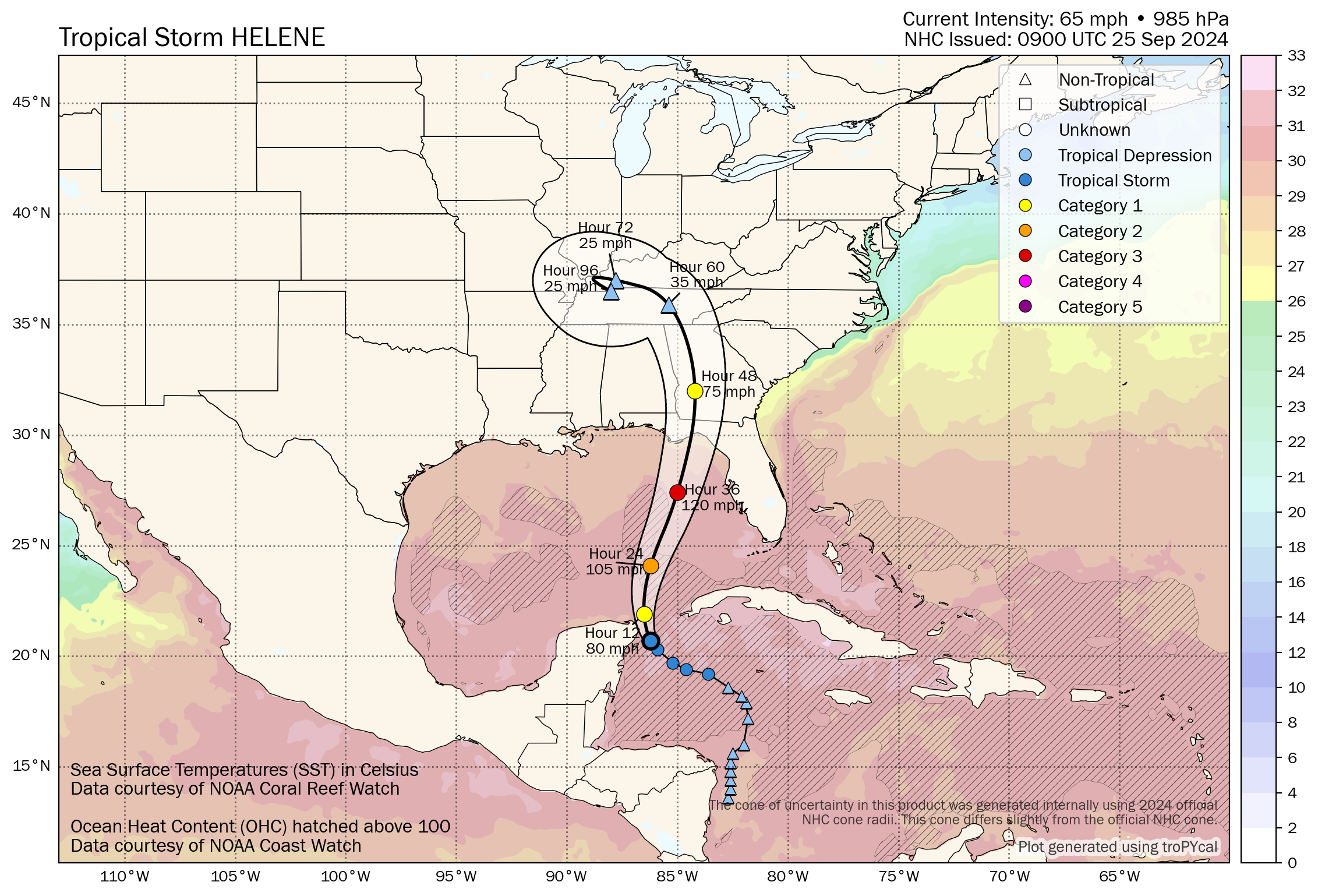
HELENE: Tropical Storm Helene has sustained winds of 65 mph early this morning and is centered about 45 miles east/northeast of Cozumel, Mexico. The system is moving northwest at 9 mph.
Over the next couple of days, Helene will be moving through an environment of low vertical wind shear and ample environmental moisture, and over waters of high oceanic heat content. All guidance forecasts steady to rapid intensification. The latest forecast calls for a 120-mph intensity by 36 hours, and this could be conservative as some of the guidance is stronger. After landfall, Helene is forecast to weaken and become post-tropical as it gets tangled up in the baroclinic system over the southeastern United States.
Helene’s wind field is predicted to grow very large in the National Hurricane Center forecast. Therefore, storm surge, wind and rainfall impacts will likely extend well away from the center and outside the forecast cone, particularly on the east side. In addition, the fast forward speed while Helene crosses the coast will likely result in farther inland penetration of strong winds over parts of the southeastern United States after landfall.
Landfall likely will come Thursday evening on the Florida coast south of Tallahassee and east of Apalachicola; Helene is expected to be a major hurricane (Category 3) with winds of 120 mph at that time. There has been very little change in the track forecast over the past 48 hours.
 Key messages:
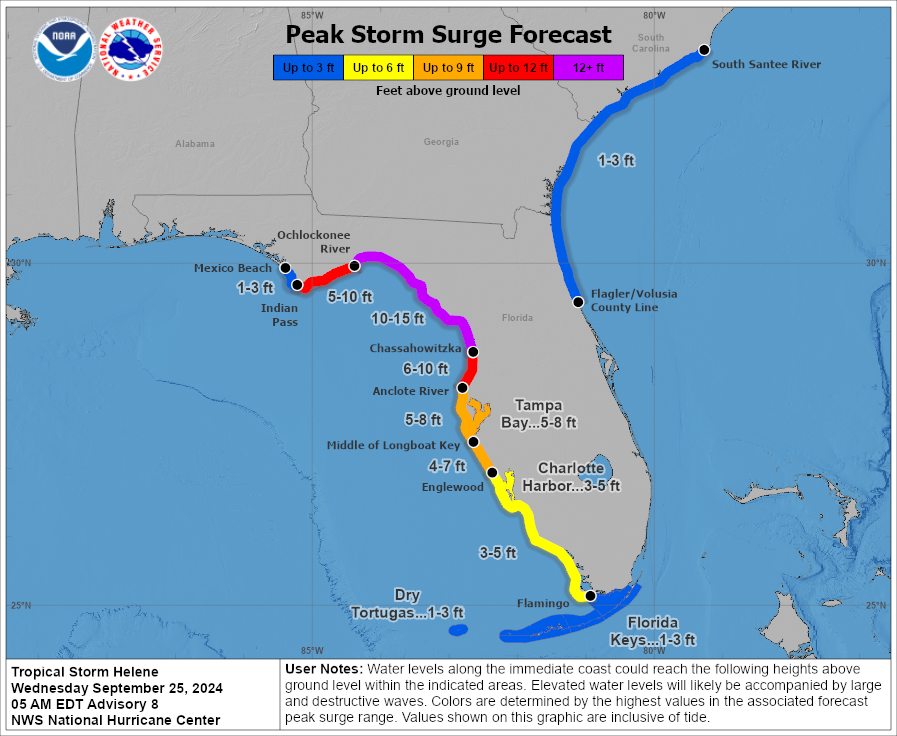
- A hurricane warning remains in effect from Anclote River to Mexico Beach.
- A hurricane watch is in effect from Englewood to Anclote River, including Tampa Bay.
- A storm surge warning is in effect for Indian Pass southward to Flamingo, for Tampa Bay and for Charlotte Harbor.
- The central Gulf Coast (Gulf Shores to Panama City Beach) is on the good, west side of the circulation with an offshore flow. The hurricane warning includes Mexico Beach, Port St. Joe, Cape San Blas and points east. The main impact in terms of wind, storm surge, flooding and isolated tornadoes will be from east of Indian Pass to Cedar Key and down to Tampa Bay (the east side of the circulation).
- A 10- to 15-foot storm surge is forecast from the Ochlockonee River down to Chassahowitzka on the Florida coast. The storm surge around Tampa Bay is forecast to be 5-8 feet.
- The southeast corner of Alabama (around Dothan) could see wind gusts to 40-45 mph Thursday night. A tropical storm warning has been issued for Houston and Henry counties. The rest of east Alabama will see gusts to 35 mph; gusts over the western half of the state will be 20-25 mph. The highest wind velocities will be east of Alabama over north Florida and Georgia.
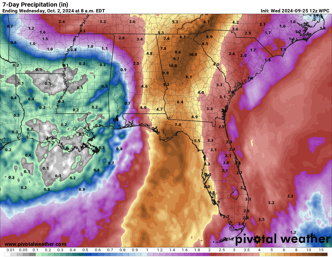
- The eastern half of Alabama has potential for 3-5 inches of rain through Friday morning; potential for the western counties is 1-3 inches. Areas in west and southwest Alabama from Tuscaloosa to Mobile are expected now to receive less than 1 inch. A flash flood watch has been issued for east and southeast Alabama, in the broad area from Gadsden and Anniston south to Dothan.
- Tornadoes are not expected in Alabama. Any isolated tornadoes will be along the east of the center of circulation as Helene moves northward east of Alabama.
- The weather will improve across Alabama by midday Friday; we expect just a few scattered, light showers Friday night and Saturday. The weather won’t be bad at all for high school and college games in the state, but a passing shower can’t be ruled out. Wind will be less than 10 mph.
Remember, any tropical forecast can change. Watch for updates.
ON THIS DATE IN 1998: Four hurricanes were spinning simultaneously in the Atlantic basin: Georges, Ivan, Jeanne and Karl. That was the first time this had happened since 1893.
For more weather news and information from James Spann and his team, visit AlabamaWx.