James Spann: Hot Alabama afternoon; some strong storms late tonight

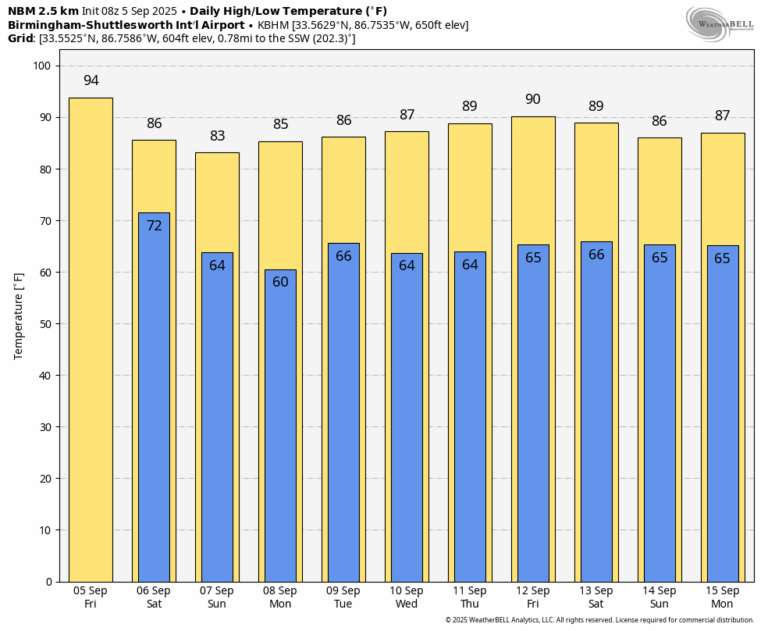
HOT SEPTEMBER DAY: Expect a partly to mostly sunny sky across Alabama today with a high in the mid 90s, about 6-8 degrees above average for early September. Showers will be few and far between during the day, but an organized band of showers and storms will creep into the state late tonight, after midnight. SPC has introduced a risk of severe thunderstorms for the northern third of the state …
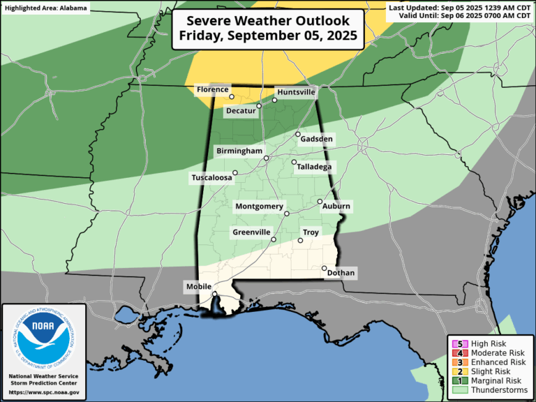
Some of the heavier storms could produce strong gusty winds as they pass through the Tennessee Valley; they will weaken by daybreak tomorrow. Showers and storms will slowly move through Central Alabama tomorrow morning, and by afternoon most of the state will be dry with just a few widely scattered showers over the southern counties. The weather looks dry tomorrow night and Sunday … highs over the weekend will be in the low to mid 80s for most communities.
NEXT WEEK: The week will feature partly to mostly sunny days, fair nights, and hardly any showers. Highs will be mostly in the 80s, lows generally in the 60s.
TROPICS: A broad area of low pressure (Invest 91L) over the eastern tropical Atlantic, associated with a tropical wave, is producing a concentrated but disorganized area of showers and thunderstorms mainly to the north of the center. Environmental conditions are favorable for development of this system, and a tropical depression is likely to form by this weekend as it moves slowly westward at 5 to 10 mph across the central tropical Atlantic. This system is likely to be near the Lesser Antilles by the middle to latter part of next week, and interests there should monitor its progress.
NHC gives this feature a 90% chance of development; the name will be Gabrielle. Global models are not in especially good agreement concerning the future (both placement and intensity) of this system, but ensemble output from the reliable European shows a fairly weak system turning north into the open Atlantic before reaching the U.S. or the Gulf.
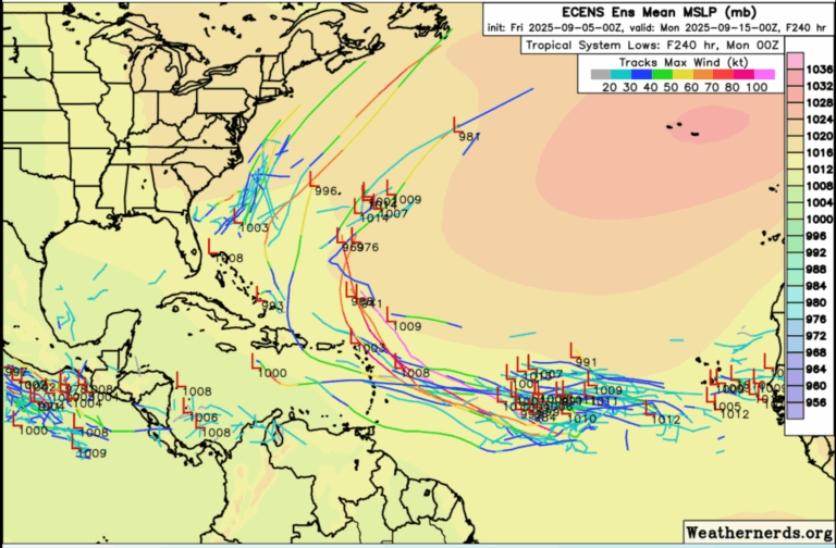
No tropical storms or hurricanes are expected across the Gulf for at least the next 7-10 days.
FOOTBALL WEATHER: Auburn hosts Ball State tomorrow evening (6:30 p.m. kickoff) … only a very small risk of a shower, otherwise mostly fair with temperatures falling through the 70s.
Alabama will host LA-Monroe tomorrow evening (6:45 p.m. kickoff) … the chance of a shower is very small, otherwise mostly fair. Temperatures will fall through the 70s during the game.
UAB will play Navy at Annapolis, Maryland Saturday (2:30 p.m. kickoff) … a passing shower or thunderstorm is possible, if not likely during the game. Temperatures will be in the low to mid 80s.
ON THIS DATE IN 1925: The temperature soared to 112F at Centreville; the hottest temperature on record in Alabama. This was part of a brutal 1925 heat wave.
ON THIS DATE IN 1996: Hurricane Fran made landfall near the tip of Cape Fear, North Carolina with maximum sustained winds near 115 mph on the evening of September 5th. Fran was responsible for 26 deaths and was at the time the most expensive natural disaster ever in North Carolina’s history.
ON THIS DATE IN 2017: Hurricane Irma became a category 5 hurricane with maximum sustained winds of 180 mph. This made Irma one of strongest hurricane ever observed in the open Atlantic Ocean.
For more weather news and information from James Spann and his team, visit the Alabama Weather Network.