James Spann: Hotter afternoons ahead for Alabama; upper 90s by Monday, Tuesday

RADAR CHECK: Scattered showers and thunderstorms are most numerous over the southern two-thirds of Alabama this afternoon; stronger storms are producing heavy rain and frequent lightning. Away from the showers, temperatures are near 90 degrees. Showers will fade after sunset.
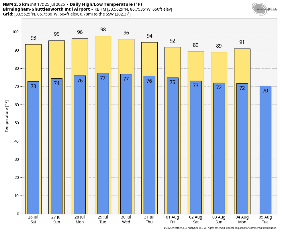
As an upper ridge begins to strengthen across the Deep South, our forecast will highlight slowly rising heat levels over the next few days. Expect a high in the low 90s Saturday and mid 90s Sunday, followed by upper 90s Monday and Tuesday. The first half of next week should feature the hottest weather so far this summer.
As heat levels rise, coverage of afternoon showers and thunderstorms will fall. The chance of any one spot seeing a shower is 25-35% today and Saturday, around 20% Sunday and 15-20% Monday and Tuesday.
The ridge weakens after Tuesday, so heat levels fall over the latter half of next week with afternoon showers and storms becoming more numerous.
TROPICS: The Atlantic basin is quiet and tropical storm formation is not expected at least for the next seven days.
ON THIS DATE IN 2020: Hurricane Hanna, the 2020 Atlantic season’s first hurricane, made landfall along the unpopulated Padre Island National Seashore, carrying sustained 90 mph winds with gusts over 100 mph. Hanna’s memory for the Rio Grande Valley will be flooding rainfall, power outages and an array of damage to poorly constructed buildings, from minor roof damage to complete demolition.
For more weather news and information from James Spann and his team, visit AlabamaWx.