James Spann: Mostly dry Tuesday for Alabama; rain returns Wednesday

RADAR CHECK: The sky has become mostly sunny over the northern two-thirds of Alabama this afternoon, but light rain lingers near the Gulf Coast. The rain over southern Mobile and Baldwin counties will fade this evening; for the rest of the state, tonight will be mostly fair and cool, with a low in the 50s.
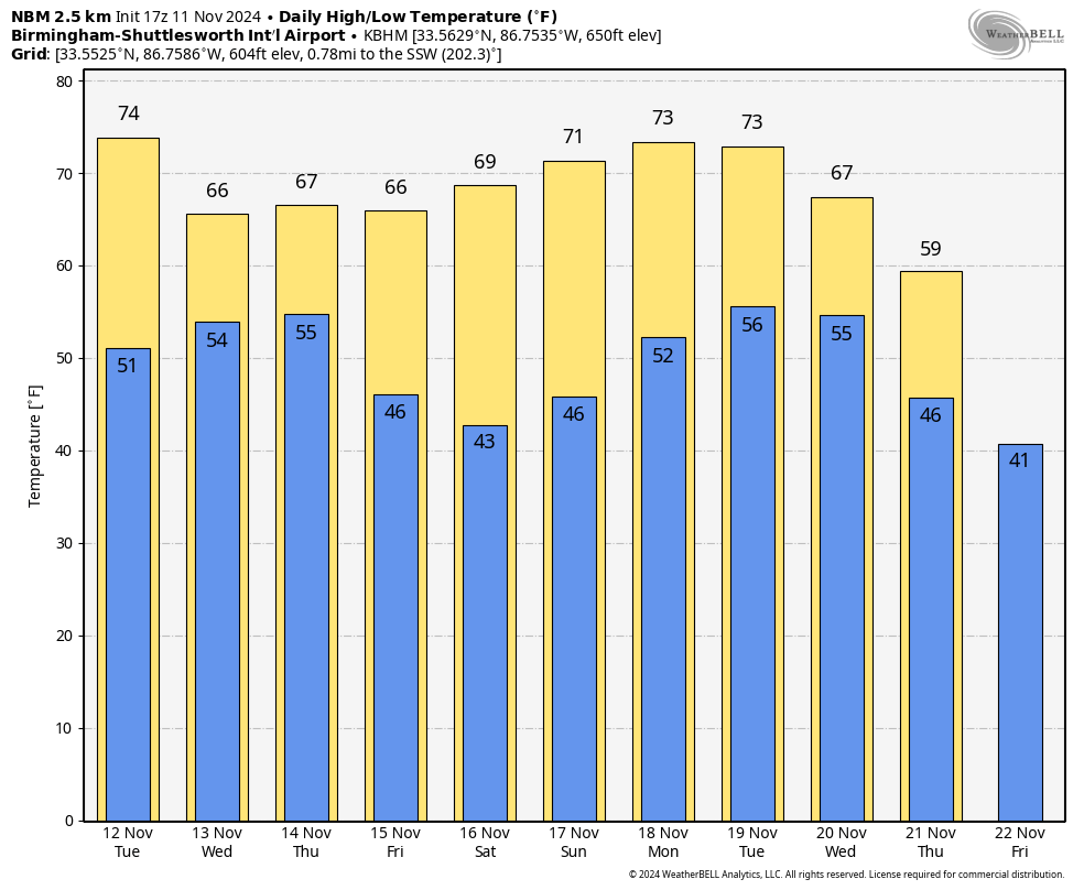
Tuesday will be mostly sunny and dry with the exception of Mobile and Baldwin counties, where a few isolated showers are possible. An upper trough and surface front will bring a chance of rain statewide Wednesday afternoon into Thursday morning. This system has potential to bring 1 inch of rain to northwest Alabama, with one-half to 1 inch for the central counties. Amounts will be less than one-half inch for south Alabama; the southeast corner of the state will see very little rain.
The high Tuesday will be in the 70s, but temperatures won’t get out of the 60s Thursday.
FRIDAY AND THE WEEKEND: Expect beautiful fall weather with sunny, pleasant days and clear, cool nights. Highs will be in the 60s Friday and close to 70 over the weekend. Lows drop into the 40s, and some colder spots over north Alabama could reach the 30s early Saturday morning.
NEXT WEEK: For now, much of the week looks dry, but some rain is possible by Friday, Nov. 22.
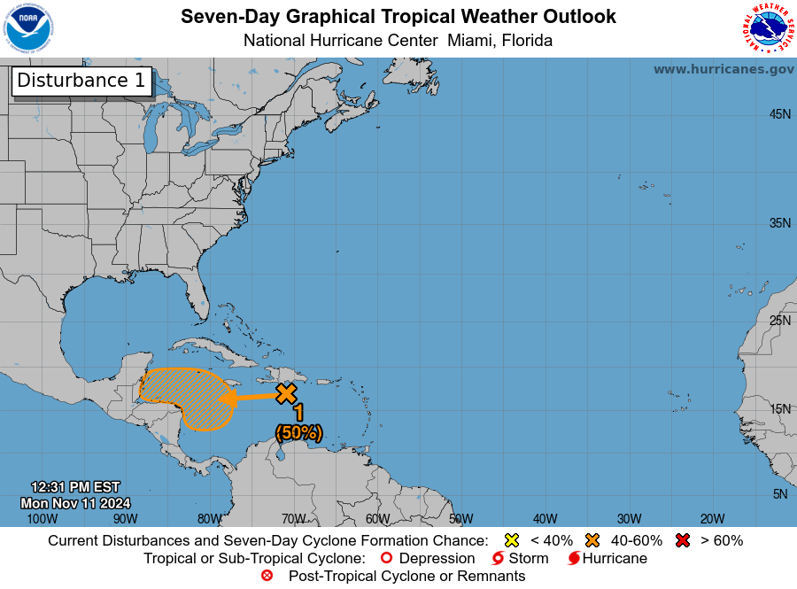
TROPICS: An area of disorganized showers and thunderstorms to the south of Hispaniola over the central Caribbean Sea is associated with a tropical wave. This system is expected to move slowly westward during the next few days, and environmental conditions appear conducive for gradual development. A tropical depression could form late this week or this weekend while meandering over the western Caribbean Sea. The National Hurricane Center gives it a 50% chance of development over the next seven days.
Long-range global models suggest that if it develops, this feature will turn to the east/northeast and could be close to the southern tip of Florida in 10 days before heading out into the Atlantic, with no impact on the central Gulf Coast. But that could easily change.
ON THIS DATE IN 1911: A powerful cold front, known as the Great Blue Norther of 1911, produced some of the most extreme temperature changes to the nation’s midsection. Ahead of the cold front, a warm, moist environment caused a severe weather outbreak, with several strong tornadoes reported in Iowa, Illinois, Indiana, Wisconsin and Michigan. An estimated F4 tornado occurred from Janesville to Milton, Wisconsin, causing extensive damage to several farms and killing nine people. The residents of Janesville, Wisconsin, reported blizzard conditions with a temperature near zero within an hour of the tornado.
For more weather news and information from James Spann and his team, visit AlabamaWx.