James Spann: Rain for south Alabama this afternoon, statewide by Wednesday night

RADAR CHECK: Areas of light rain continue moving across the southern quarter of Alabama this afternoon, but the northern half of the state is dry with sunshine in full supply. Clouds will increase across north Alabama tonight; lows will be between 55 and 62 degrees.
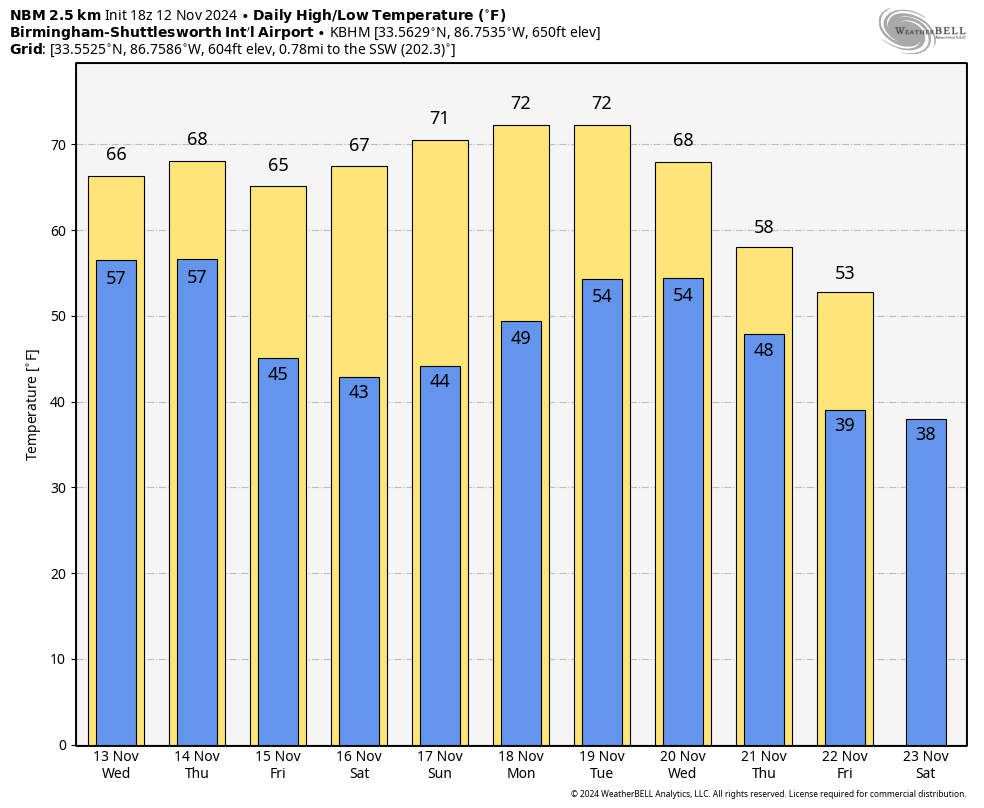
The sky will be mostly cloudy Wednesday ahead of an upper trough, and periods of rain are likely Wednesday afternoon into Thursday, mainly during the morning. Amounts could exceed 1 inch for the northern third of the state. Highs will be mostly in the 60s Wednesday and Thursday.
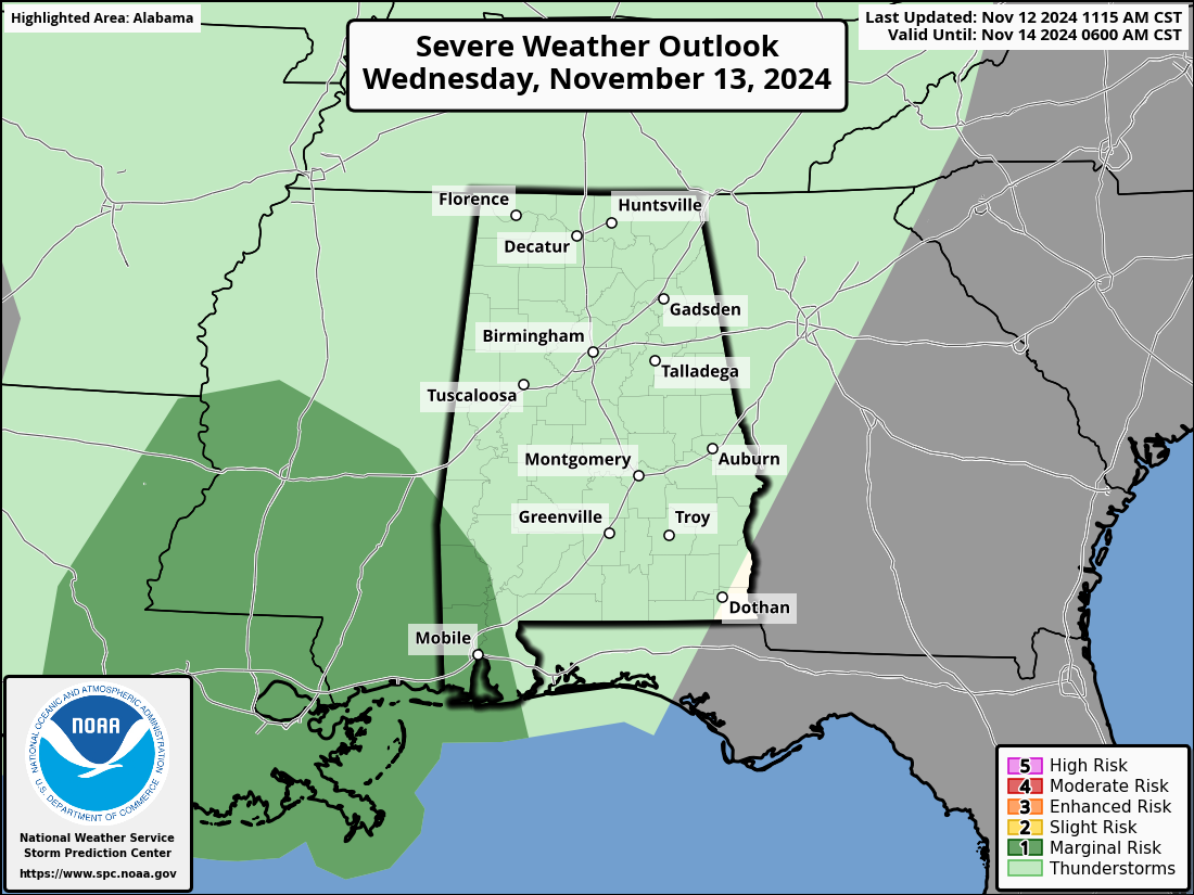
The Storm Prediction Center has defined a marginal risk of severe thunderstorms for the southwest corner of Alabama late Wednesday and Wednesday night. Heavier storms there could produce strong, gusty winds. A brief, isolated tornado can’t be ruled out.
FRIDAY AND THE WEEKEND: Nights will be noticeably cooler, with lows mostly in the 40s, but some of the colder spots across north Alabama will reach the mid to upper 30s early Saturday morning. Look for sunny, pleasant days with highs in the 60s Friday and between 67 and 73 degrees over the weekend.
NEXT WEEK: The weather stays dry for the first half of the week, but a dynamic weather system will bring some risk of rain and possible thunderstorms to the Deep South by Thursday night and Friday. For now, the severe weather threat looks low, and much colder air will arrive Friday as a cold-core upper low sets up over the region.
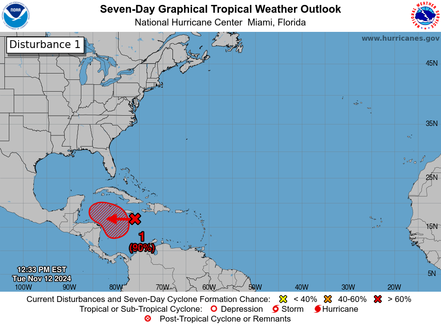
TROPICS: Disorganized showers and thunderstorms over the central Caribbean Sea are associated with a broad area of low pressure. Environmental conditions appear conducive for development, and a tropical depression is likely to form within the next two to three days while the system moves slowly westward into the western Caribbean Sea. Afterward, further development is likely while the disturbance meanders over the western Caribbean Sea through the weekend. The system is forecast to begin moving slowly northwestward by early next week.
The National Hurricane Center gives the system a 90% chance of development; the name will be Sara. Most global model ensemble members take it into the southern Gulf of Mexico, followed by a turn to the northeast, in the general direction of the southern Florida Peninsula. Intensity guidance suggests Sara has potential to become a significant hurricane, but it is way too early to know the track or intensity, or the specific impact on any part of Florida.
There is a very high probability Sara remains well south of the central Gulf Coast (Gulf Shores to Panama City Beach). Once the system becomes organized and we begin to get data from hurricane hunter aircraft, we will be able to bring you a track and intensity forecast.
ON THIS DATE IN 1970: The deadliest tropical cyclone ever recorded and one of the deadliest natural disasters in modern times occurred in East Pakistan, now Bangladesh. The Bhola Cyclone first formed over the Bay of Bengal on Nov. 8 and traveled north. This cyclone reached peak intensity, Category 3, on Nov. 11 and made landfall on the coast of East Pakistan the following afternoon. The Bhola Cyclone killed an estimated 500,000 people.
For more weather news and information from James Spann and his team, visit AlabamaWx.