James Spann: Showers, storms for Alabama today; dry air returns Friday night

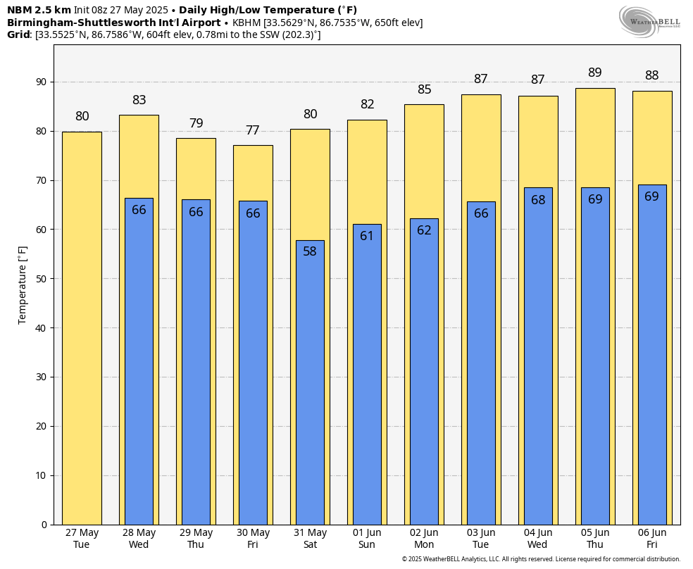
RADAR CHECK: Most of Alabama is dry early this morning with only a few isolated showers. Expect a mix of sun and clouds today with showers and storms developing by late morning and into the afternoon. Like recent days, heavier storms will be capable of producing strong, gusty winds and small hail. Temperatures reach the low 80s over north Alabama, with mid to upper 80s for the southern counties.
Showers and storms remain possible Wednesday and Thursday as the unsettled pattern continues; it won’t rain all day, and the sun will be out at times with highs in the upper 70s and low 80s.
FRIDAY AND THE WEEKEND: A cold front will push into Alabama Friday with a continued threat of showers and thunderstorms, but by afternoon the best chance of rain shifts into south Alabama as dry air pushes into the northern counties. For now, we expect rain-free weather for the state Friday night and Saturday with lower humidity. Most north Alabama communities will dip into the 50s early Saturday morning, and with sunshine in full supply the high Saturday afternoon will be between 77 and 83 degrees.
Global models suggest another batch of showers and storms will move through the state late Sunday and Sunday night.
NEXT WEEK: The weather next week will trend drier and warmer as an upper ridge builds across the region. Most days will be dry with afternoon highs approaching 90 degrees over the latter half of the week.
WET MAY: Here are rain totals across Alabama since May 1:
- Tuscaloosa — 12.93 inches
- Huntsville — 9.46
- Birmingham — 9.23
- Anniston — 8.76
- Montgomery — 8.06
- Mobile — 7.29
- Muscle Shoals — 4.89
- Dothan — 4.4
ON THIS DATE IN 1973: A long-track EF-4 tornado touched down northeast of Demopolis and traveled northeastward. A great amount of damage occurred in Greensboro, Brent, Centreville, Montevallo, Columbiana, Wilsonville, Childersburg and many areas in between. The tornado finally lifted near Mount Cheaha after creating a path of damage more than 139 miles long and up to 800 yards wide at its largest. Six people were killed and another 128 were injured along the path, including Brent, where five lost their lives and 56 were injured when the town was almost destroyed. Another person died and 72 were injured in Greensboro. A grand total of 216 buildings were destroyed, 570 buildings damaged, 97 mobile homes destroyed and 45 businesses either damaged or destroyed. Along with all of the structural damage, more than 12,000 acres of timber was destroyed.
The National Weather Service radar facility near Brent was heavily damaged by the tornado; the radar dish was blown from its tower and lay on the ground about 20 feet from the office. The roof was two-thirds gone, and the rest of the building looked as if it had been sandblasted.
Another large tornado touched down northeast of Tarrant at approximately 5:50 p.m. and started on its path of causing great damage. The first major location it hit was Center Point, where most of the damage occurred. Thirty-two frame homes were destroyed, along with 48 mobile homes, and more than 300 homes sustained damage. One person lost his life as he and his family were taking shelter in their basement and the home collapsed. The tornado continued northeast, passing close to St. Clair Springs, just south of Springville and north of Ashville, before lifting near Gadsden. The damage path was estimated at 50 miles and was 800 yards wide at its widest. Wind speeds were estimated at 162-209 mph.
For more weather news and information from James Spann and his team, visit AlabamaWx.