James Spann: Showers/storms return tomorrow; frigid air arrives Sunday night/Monday
ONE MORE DRY DAY: With a partly to mostly sunny sky temperatures rise into the 70s again today across Alabama. Clouds will increase tonight ahead of a surface front, and we will bring in a chance of showers and thunderstorms tomorrow.
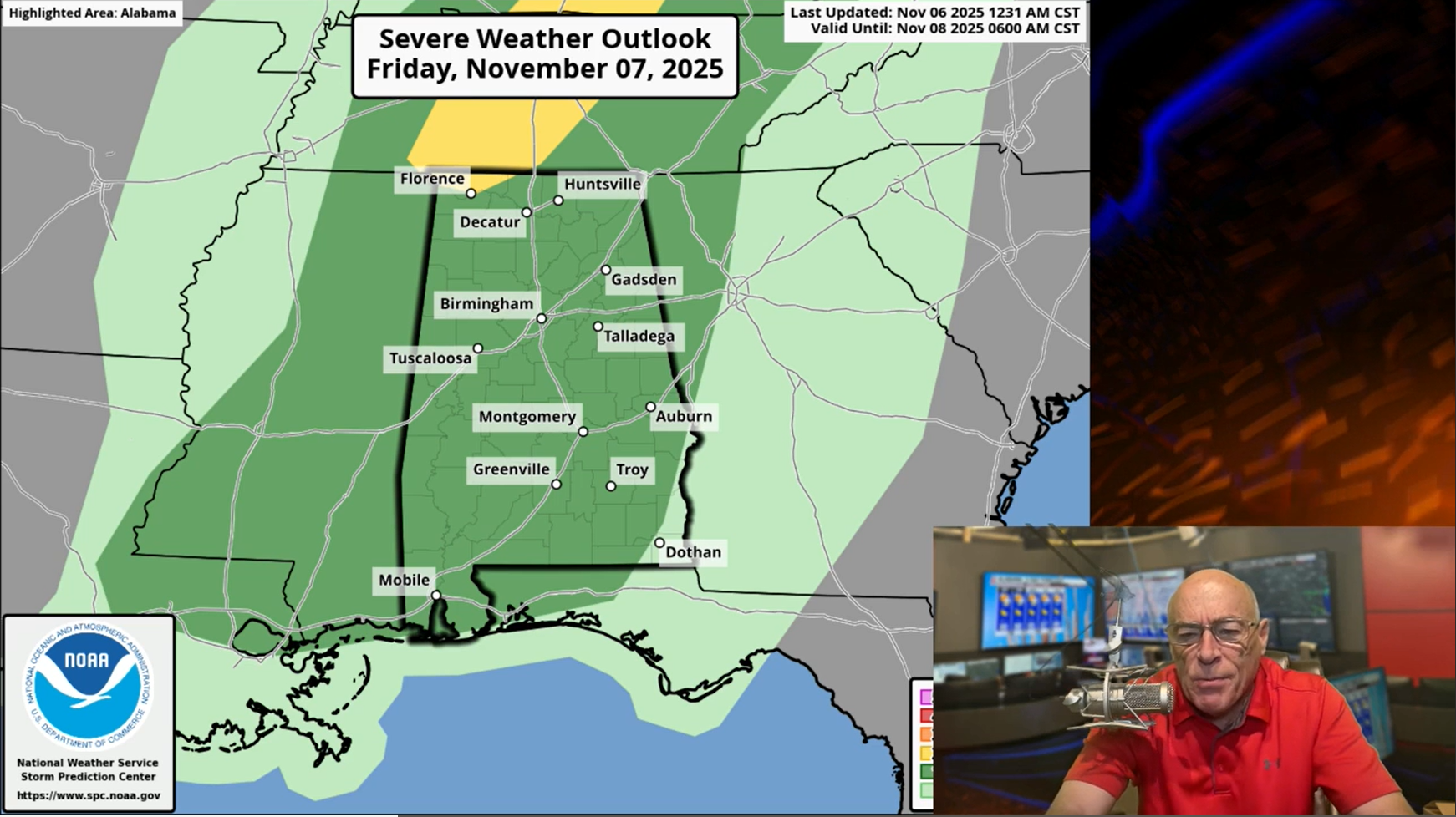
High resolution models suggest the main chance of rain during the day will be over the southern two-thirds of the state, generally south of I-20. Then, tomorrow night a band of showers (and possibly a thunderstorm) will move into the Tennessee Valley as the front drops southward.
The Storm Prediction Center has defined a low end “marginal risk” (level 1 out of 5) of severe thunderstorms for most of Alabama tomorrow, but the overall severe weather threat looks low with limited instability and weak dynamics.

THE ALABAMA WEEKEND: The weather will be mostly dry across Alabama Saturday and Saturday night, although a few isolated showers can’t be ruled out. The weather stays mild with highs in the 70s with a mix of sun and clouds. An Arctic cold front will move through early Sunday; in advance of that a few showers and a thunderstorm are possible late Saturday night into early Sunday morning, but with limited moisture rain amounts should be light and spotty.
A brisk north wind will follow the frontal passage Sunday with falling temperatures over the northern half of the state. Sunday afternoon temperatures will range from the mid to upper 40s near the Tennessee state line to the low 70s over far South Alabama. The cold air will keep dropping southward Sunday night, and the Deep South goes into the deep freeze early next week.
COLD! Monday will be a cold, blustery day with temperatures only in the 30s and 40s during the day; a brisk north wind will make it feel colder. And, a few snow flurries are possible over the northeast corner of the state (no accumulation or impact). Best chance of seeing a few snow flakes are across Madison, Jackson, Marshall, DeKalb, and Cherokee counties.
By Tuesday morning with a clear sky and light wind a freeze is likely statewide. The only part of Alabama that will stay above freezing is southern Mobile and Baldwin counties south of I-10 … but even there mid 30s are likely. Most of the state will be in the 20s; a few colder spots over the northern counties could actually dip into the upper teens.
The rest of the week will be dry with a warming trend … highs will be close to 70 by Thursday and Friday. See the video briefing for maps, graphics, and more details.

TROPICS: The Atlantic basin remains quiet and tropical storm formation is not expected for at least the next seven days.
FOOTBALL WEATHER: Saturday Auburn plays Vanderbilt in Nashville (3 p.m. kickoff) … with a partly to mostly sunny sky temperatures will fall from the low 70s at kickoff into the upper 60s by the final whistle. The chance of a shower is very small.
Alabama will host LSU Saturday night at Bryant-Denny Stadium/Saban Field (6:30 p.m. kickoff). The sky will be mostly cloudy, and we will mention a small risk of a passing shower during the game. Temperatures will fall slowly through the 60s.
ON THIS DATE IN 1885: A devastating tornado moved 30 miles through Dallas County. It moved north-northeast, 4 miles west of Selma. Tenant homes and numerous trees were leveled. “At least 30 homes, most of very poor construction, were swept away, and a half-mile swatch of forest was flattened.” Thirteen were killed and at least 400 injured.
ON THIS DATE IN 1977: Several possible causes lead to the collapse of the Kelly Barnes Dam in Georgia. The failure allowed a 40-acre lake to flood the Toccoa Falls College, killing 39 people and injuring 60 more. The dam was never rebuilt.
For more weather news and information from James Spann and his team, visit the Alabama Weather Network.