James Spann: Strong to severe storms possible Tuesday night across north Alabama

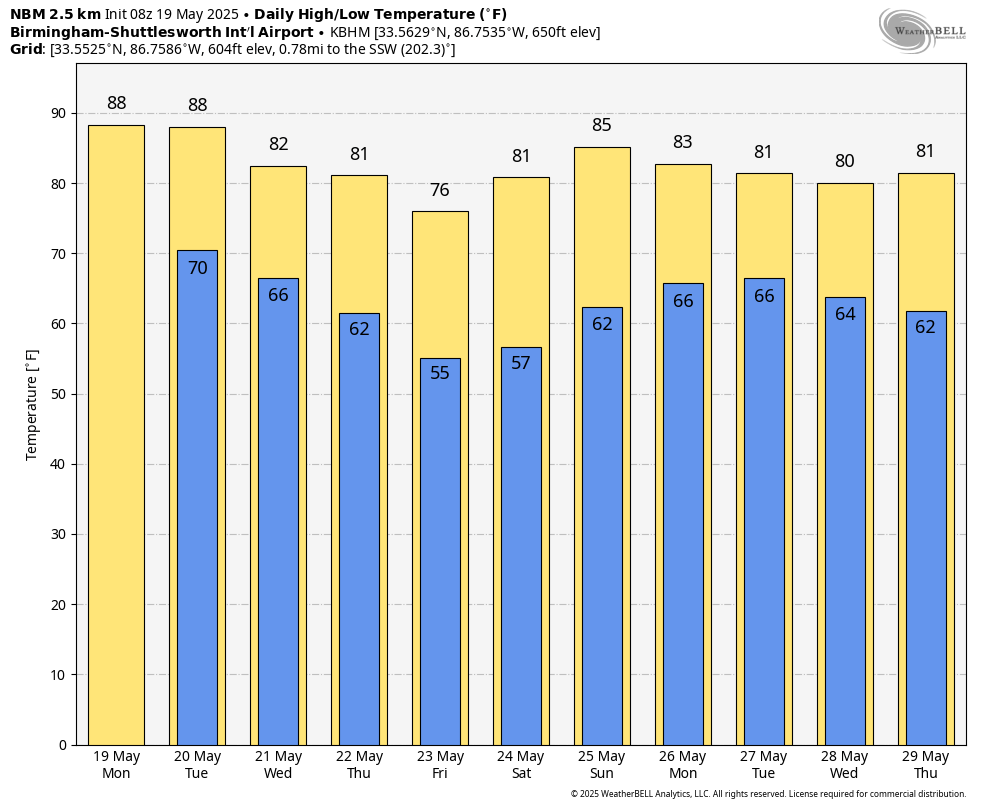
RADAR CHECK: Patches of mostly light rain are over far north Alabama early this morning in the wake of stronger storms that moved through before dawn. The rest of the state is dry at daybreak. With a mix of sun and clouds, we expect a high between 86 and 90 degrees today with just a few isolated showers or storms this afternoon and tonight; most places will be rain-free.
The day Tuesday will be partly sunny and very warm, with highs in the upper 80s. Any showers will remain isolated.
TUESDAY NIGHT: The Storm Prediction Center has defined an enhanced risk (level 3 out of 5) of severe thunderstorms for northwest Alabama. There is a slight risk (level 2) down to Greensboro, Calera and Heflin, and a marginal risk (level 1) as far south as Thomasville, Prattville and Lafayette.
A line of severe thunderstorms will likely enter the northwest corner of the state around 6 p.m. and will move through the northern half of the state Tuesday night. Here are the key messages:
- The primary threat will come from damaging winds, since high-resolution models suggest the storms will be linear. However, a few isolated tornadoes are certainly possible within the line as well. If any discrete storms form ahead of the line, the tornado risk will be higher.
- Large hail is also possible in a few spots.
- The line of storms should reach Tuscaloosa, Birmingham, Gadsden and Anniston in the 9-11 p.m. time frame.
- The storms will likely weaken over central Alabama after midnight as the upper support moves away.
REST OF THE WEEK: A few lingering showers are possible over south Alabama early Wednesday, but most of the state will be dry with a high in the low 80s. Most communities will stay rain-free Thursday with just a few isolated showers over the Tennessee Valley. Friday will be sunny and very pleasant statewide; some of the cooler spots over north Alabama could reach the upper 40s early Friday morning. Highs will be in the 70s over the northern counties of the state, with low 80s to the south.
MEMORIAL DAY WEEKEND: South Alabama will be generally dry over the holiday weekend, but a few scattered showers will be possible over the northern third of the state Saturday and Sunday as moisture levels rise. Showers and storms are more likely Monday with the approach of a cold front.
ON THIS DATE IN 1915: A spring storm came to an end after producing widespread snow. Total snowfall from the storm included 17.6 inches in Scottsbluff, Nebraska, 8 inches at Cheyenne, Wyoming, 7 inches at Chadron and 3.9 inches in North Platte, Nebraska.
ON THIS DATE IN 1973: An F2 tornado chewed its way across northern Fort Payne, injuring 35 people. Other tornadoes touched down the same day in parts of Madison and Jackson counties.
For more weather news and information from James Spann and his team, visit AlabamaWx.