Scott Martin: Alabama heats up this weekend as rain chances increase in the work week

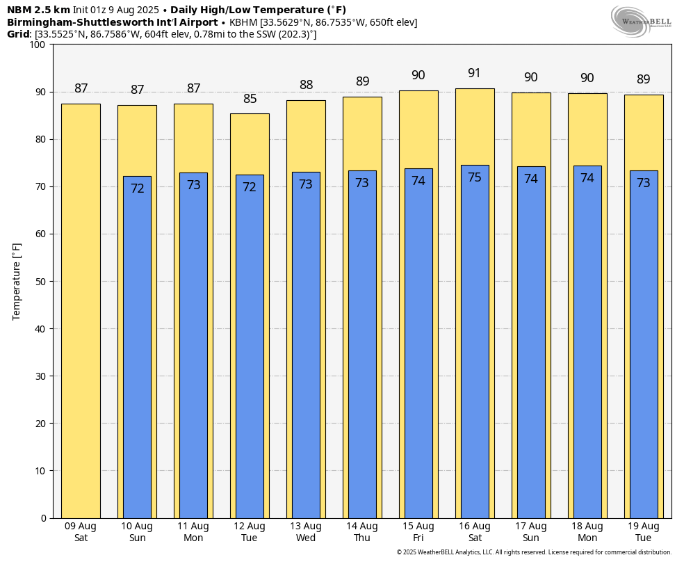
SATURDAY: Folks, today’s going to be a good-looking summer day for most of us. High pressure is sittin’ right on top of Alabama, and that’s gonna keep the sky mostly sunny and the showers few and far between. The only real chance of a stray shower will be way down south, south of I-85, and even there it’s a slim shot. Highs will run in the lower 90s west of I-65, with upper 80s over in east and southeast Alabama where we’ll see a few more clouds. Tomorrow night, lows in the upper 60s to low 70s. You might see some patchy fog in the valleys at sunrise, but most places stay clear thanks to a light breeze.
SUNDAY: Now Sunday — that’s going to be our hottest day of the week. Some spots up in northwest Alabama might hit 94, maybe 95 degrees. The heat index? Upper 90s, pushing right up around 100. A weak front will slip into the state from the north and east, and that could fire up a few afternoon showers and storms, especially south of U.S. 278. Odds are in the 20-30% range. Any storms that form will fade quickly once the sun goes down. Another warm night ahead — upper 60s to low 70s — with light winds keeping most fog away.
MONDAY: That front will creep a little farther north Monday, and that means a better chance of scattered showers and storms just about anywhere. We’ll call it a 30-45% coverage. Most of these will be your standard summer afternoon boomers — heavy rain, lightning, maybe some gusty winds. Highs will be upper 80s to low 90s, warmest in the western counties. After sunset, storms wind down, but some patchy fog could pop up in valleys before daybreak Tuesday.
TUESDAY: Tuesday brings a stronger weather system inching closer from the west, pulling up plenty of Gulf moisture. That’s going to fuel more widespread showers and storms, mainly in the afternoon and evening. Clouds and rain will keep highs mostly in the mid to upper 80s, though a few spots might sneak up to 90. Any storm could drop a quick soaking, so keep an umbrella handy.
WEDNESDAY: Here’s where things get more active. That front edges closer, and with all the moisture in place, we’ll have a good coverage of showers and storms across the state. We may even see multiple rounds in some areas. Heavy downpours could lead to localized flooding, so be mindful of those low-lying spots and poor drainage areas. Highs in the mid to upper 80s. No big organized severe threat, but a storm or two could still pack some gusty winds.
THURSDAY: Thursday looks wet — very wet for some of us. The front hangs around, the Gulf moisture keeps flowing in, and we’ll see numerous showers and storms. Some areas could pick up a couple inches of rain in just a few hours, so flash flooding becomes a real concern. Keep that in mind if you’ve got to drive through any flood-prone areas. Highs again mid to upper 80s with more clouds than sun.
FRIDAY: By Friday, the front will be drifting through or stalling nearby. Rain chances will stay up — maybe not quite as high as Thursday — but still scattered to numerous showers and storms. Highs hold steady in the mid to upper 80s. If that front lingers into the weekend, we’ll keep the unsettled pattern going right on into Saturday and Sunday.
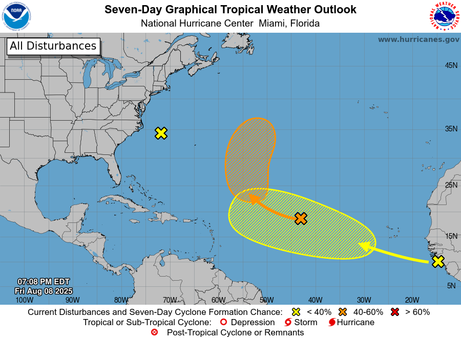
TROPICS: Out in the tropics, there’s a non-tropical low off the Carolina coast with disorganized showers. It will be moving over cooler waters soon, and there’s no chance of development in the next week. In the central Atlantic, we’re watching Invest 96L — a tropical wave with some showers, but dry air will limit it for now. By early or mid-next week, conditions improve and there’s a 40% chance it could become a tropical depression while moving northwest to north. Farther east, another tropical wave just off Africa has a large area of storms, but development looks slow with only a 20% chance over the next week as it moves west-northwest across the Atlantic. At this time, there are no immediate tropical threats to the Gulf, but in August, we always keep one eye on the Atlantic.
For more weather news and information from Scott Martin and the rest of the James Spann team, visit AlabamaWx.com.