Scott Martin: Strong start for summer in Alabama as heat builds, storm chances fade

SUMMER BEGINS: Today marks the official start of summer — and it’ll feel like it. After some early morning fog burns off, skies will be mostly sunny with just a slight chance of a popup storm, mainly in southwest Alabama. With a ridge building and more sunshine, temperatures will climb quickly, and the heat index could top 100 degrees in some western counties. Summer officially begins tonight at 9:42 p.m. Highs will reach the upper 80s to mid 90s.
THE WEEKEND: Saturday brings the next step up in the heat and humidity. Temperatures will climb into the 90s across most of the state, and with dewpoints staying high, it’ll feel closer to 100 degrees or higher in many spots. A stray afternoon thunderstorm can’t be ruled out, especially across northwest Alabama, but most will stay dry under strong upper-level ridging. Highs will range from the upper 80s to upper 90s.
Sunday kicks off a stretch of real summer weather — hazy, hot and humid. The ridge aloft will dominate, and with high dewpoints and very little wind, the air will feel oppressive by afternoon. The heat index will climb into the 100- to 105-degree range, and we’ll be watching closely for the need for a heat advisory by Sunday or Monday. A very isolated afternoon storm may pop up, but most of Alabama will stay dry and sweltering. Highs will be in the lower to mid 90s.
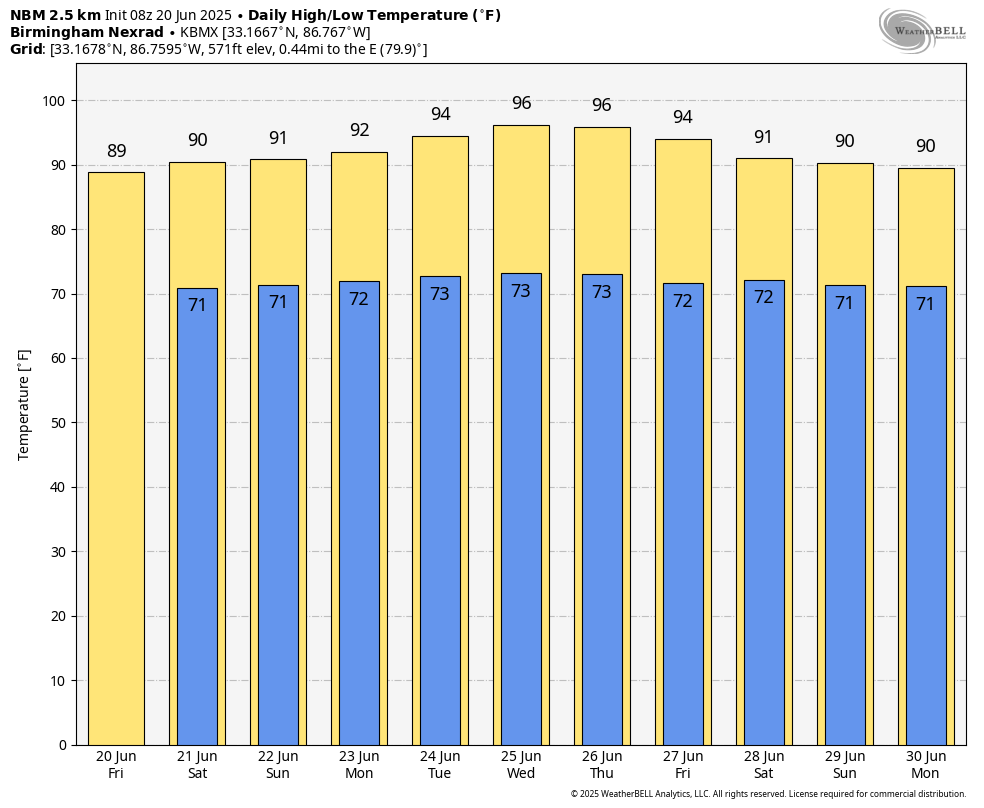
THE WORK WEEK: Monday continues the same pattern — hot, humid and mostly dry. The heat index will again flirt with or exceed 100 degrees in many areas, and overnight lows in the 70s won’t offer much relief. This kind of heat puts stress on anyone without access to shade, water or air conditioning, so heat safety becomes increasingly important. Isolated storms remain possible in the afternoon, but coverage will be low. Highs will stay in the lower to mid 90s.
Tuesday is likely to be one of the hottest days so far this year. A strong ridge centered to our north will keep the atmosphere stable and limit storm development. Expect highs climbing well into the mid to upper 90s, with heat indices well over 100 degrees for most of Alabama. Dewpoints will remain elevated, and the combination of heat and humidity could push parts of the state into the major heat risk category. Highs will be mostly in the mid to upper 90s.
Wednesday keeps the heat cranked up. Sunshine and southwest flow will keep dewpoints elevated and temperatures soaring again. There’s still a low-end chance of an isolated storm in the afternoon, but many areas will remain dry. The heat index will again be near or above 100 degrees, with little overnight relief. Highs will hold in the mid to upper 90s.
Thursday brings only minor relief. A few models hint at slightly more moisture and perhaps an increase in isolated afternoon storms, but most of the state will remain locked in a hot, humid pattern. The heat index will stay elevated, and the ground moisture from recent rain may help limit mixing, keeping humidity levels high. Highs will be mostly in the lower to mid 90s.
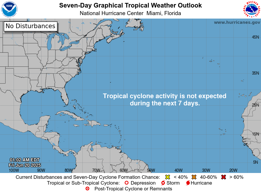
TROPICS: For the North Atlantic, Caribbean Sea and the Gulf of Mexico, tropical cyclone formation is not expected during the next seven days.
For more weather news and information from James Spann, Scott Martin and other members of the James Spann team, visit AlabamaWx.