Alabama-built Army Corps of Engineers vessels honor fallen Georgia soldiers

The U.S. Army Corps of Engineers, Savannah District, has completed final inspections of three new hydrographic survey vessels at the Fowl River Marina in Theodore, Alabama.
Each vessel was built by Silver Ships in Theodore and bears the name of a fallen U.S. Army Soldier from Georgia, serving as a lasting tribute to their sacrifice and service.
The 30-foot Wright is named for Staff Sgt. Dustin Wright, the 27-foot Chisholm for Sgt. Tyrone Lanard Chisholm and the 23-foot Beale for Sgt. 1st Class John C. Beale.
The vessels were procured with 2023 funds, and it took two years to build the vessels to meet the District’s needs.
The inspections were carried out to identify and address any remaining deficiencies and to make final adjustments before the District accepts the vessels from the manufacturer.
During the inspections, District personnel thoroughly evaluated each vessel to confirm proper installation and functionality of all equipment, and ensure the vessels meet required performance and safety standards.
“We checked to make sure critical systems such as the radar, chart plotters, radios, lights and generators work properly,” explained Jim Bodenrader, maintenance and mobile equipment operation supervisor with the Savannah District. “We also tested the vessels’ steering and verified that increasing the revolutions per minute of the outboard motors resulted in corresponding increases in speed.”


The inspection revealed only minor deficiencies, which will be corrected before delivery. Once finalized, the vessels will be transported to the District’s Coastal Project Office along the Savannah River, in Savannah, Georgia.
There, the vessels will support a variety of critical missions, including surveys to assess channel conditions, monitoring dredging activities and underwater obstacle detection. They will also transport staff and equipment to project sites.
The vessels will play a vital role across the Savannah District’s area of responsibility, which includes key waterways, such as the Savannah Harbor, the third busiest container port in the U.S.; the Brunswick Harbor, the largest roll-on/roll-off port; and the 161-mile stretch of the Atlantic Intracoastal Waterway along Georgia’s coast.
“These new vessels are a significant upgrade in efficiency, safety and capability compared to the ones they’re replacing,” Bodenrader said. “The older boats were not originally designed for survey operations and are equipped with outdated technology. The new vessels are purpose-built to meet the demands of our mission and are outfitted with state-of-the-art equipment.”
Some of the high-tech equipment onboard the vessels include radar systems, chart plotters, navigation lights and interferometric multibeam sonar.
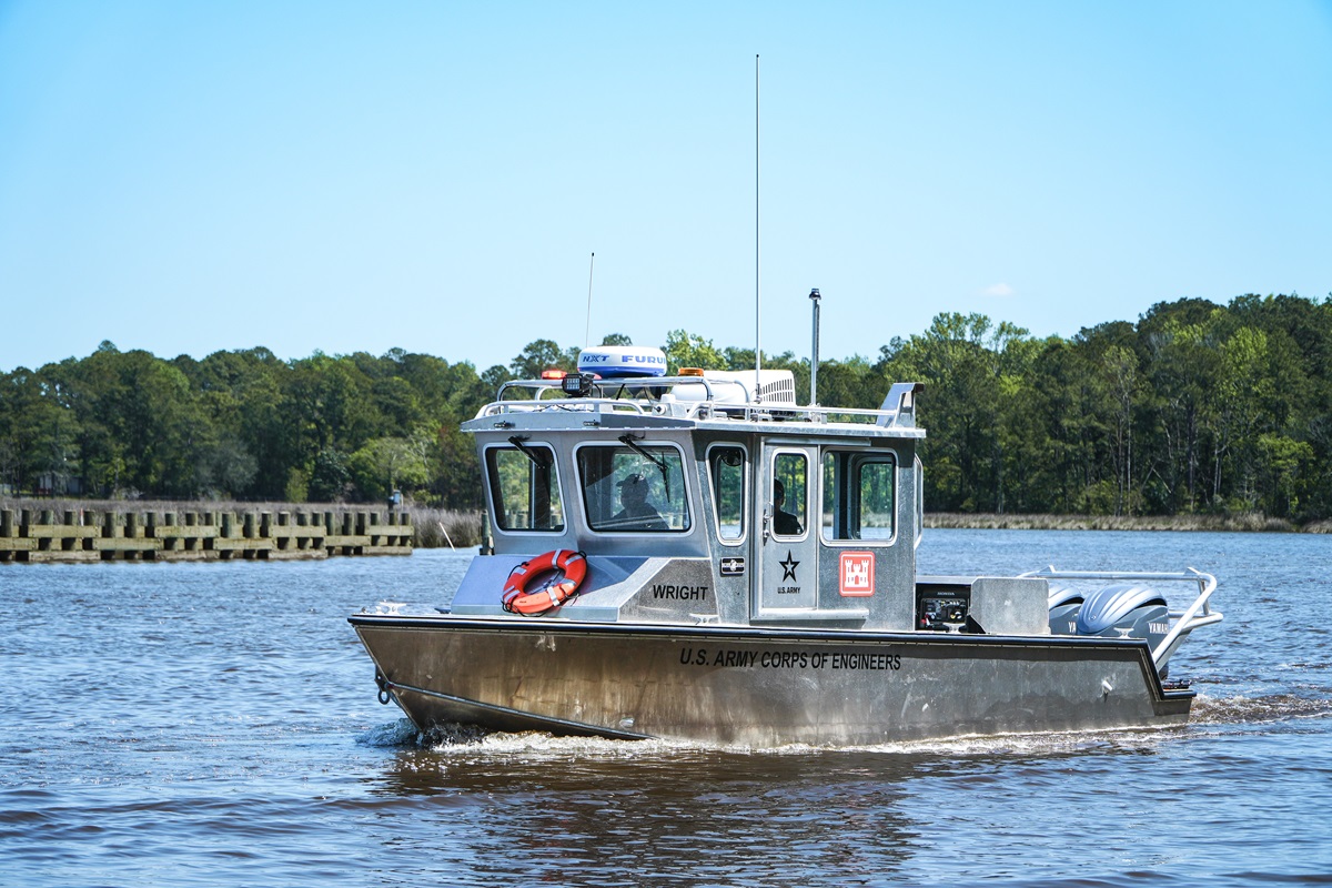
Silver Ships in Theodore, Alabama, built the 20-foot Freedom 26 Wright. The vessel bears the name of fallen U.S. Army Soldier Staff Sgt. Dustin Wright. (Silver Ships)
Radar on boats is primarily used for navigation and collision avoidance, particularly in situations with limited visibility like fog, rain, or at night. It detects objects around the boats using radio waves, helping to identify other vessels, landmasses and potential hazards.
Chart plotters are devices used in marine navigation that integrate GPS data with electronic navigational charts to display real-time position and movement of boats on a screen.
Navigation lights, also known as nav lights or running lights, are colored lights displayed on boats to indicate their size, activity and direction of travel, helping other boaters avoid collisions, especially at night or in low visibility conditions.
“The interferometric multibeam is a fusion between a side scan sonar system and a multibeam sonar system,” explained Miles Saunders, chief of hydrographic survey, with the District’s Coastal Projects Office. “This new sonar system, which will be installed on the Beale, excels in shallow water and will greatly facilitate our work in upper estuaries and Atlantic Intracoastal Waterway.”


All three vessels are also equipped with automatic identification systems. This is a maritime safety technology that works by broadcasting a vessel’s identity, location, course, speed and other relevant data, allowing other vessels and shore-based facilities to track and monitor its movements.
“The AIS is an added layer of safety,” Bodenrader said. “If something were to go wrong, we’d immediately know the vessel’s location.”
The Chisholm is additionally outfitted with a bow gate, which is a ramp for loading and unloading cargo and personnel from the vessel to shore. This feature allows the vessel to be used as a landing craft.
“There are places within our AOR that we cannot access by road,” Bodenrader said. “Now we can transport USACE team members vehicles and other assets to those areas with less difficulty.”